Beolgyo night lights from space
Night Light of Beolgyo (Jeollanam-do) from space (South Korea) Src. Average luminocity for 10x10km area is 15.3498% and for 50x50km: 9.0427%.
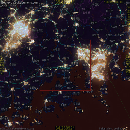
Analysis of Beolgyo night lights 2016
Square area 10x10 km:
 0%
0%90-99
4.03%80-89
2.38%70-79
1.28%60-69
2.2%50-59
0.73%40-49
3.3%30-39
1.65%20-29
2.38%10-19
2.38%0-9
79.67%Square area 50x50 km:
0.88%90-99
1.68%80-89
1.13%70-79
1.2%60-69
1.18%50-59
1.45%40-49
1.1%30-39
1.9%20-29
2.82%10-19
4.35%0-9
82.31%Clear (daylight) street map image can be seen on geolist.org.
Map coordinates:
35° 25' 26.3" North, 126° 38' 14.6" East
34° 50' 56.3" North, 127° 20' 25.9" East
34° 16' 11.7" North, 128° 2' 37.1" East
Some cities around Beolgyo sort by population:
• Gwangju
51.5 km =32 mi,  311°
311°
• Masan
55.7 km =34.6 mi,  303°
303°
• Yeosu
31 km =19.3 mi,  108°
108°
• Suncheon
17.5 km =10.9 mi,  49°
49°
• Kwangyang
26.7 km =16.6 mi,  58°
58°
• Hwasun
39.9 km =24.8 mi, 306°
• Yeongam
59 km =36.7 mi,  264°
264°
• Kurye
41.6 km =25.8 mi,  15°
15°
1839011 (p: 19,842)
Sources (retrieved 2019-11-25):
» Earth at Night: Flat Maps 2012, 2016