Cholpon-Ata night lights from space
Night Light of Cholpon-Ata (Issyk-Kul) from space (Kyrgyzstan) Src. Average luminocity for 10x10km area is 2.3818% and for 50x50km: 0.2406%.
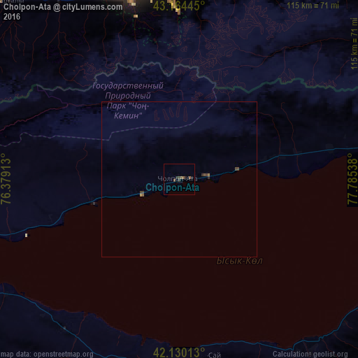
Analysis of Cholpon-Ata night lights 2016
Square area 10x10 km:
 0%
0%90-99
0%80-89
0%70-79
0%60-69
0.45%50-59
1.97%40-49
0.3%30-39
0.45%20-29
2.27%10-19
0%0-9
94.55%Square area 50x50 km:
0%90-99
0%80-89
0%70-79
0.03%60-69
0.05%50-59
0.1%40-49
0.11%30-39
0.08%20-29
0.15%10-19
0%0-9
99.49%Clear (daylight) street map image can be seen on geolist.org.
Map coordinates:
43° 9' 52" North, 76° 22' 44.9" East
42° 38' 58" North, 77° 4' 56.1" East
42° 7' 48.5" North, 77° 47' 7.4" East
Some cities around Cholpon-Ata sort by population:
• Almaty, KZ
68.7 km =42.7 mi,  349°
349°
• Talghar, KZ
73.9 km =45.9 mi,  10°
10°
• Balykchy
76.3 km =47.4 mi,  253°
253°
• Esik, KZ
84 km =52.2 mi,  20°
20°
• Burunday, KZ
80.7 km =50.1 mi, 346°
• Otegen Batyra, KZ
85.8 km =53.3 mi,  356°
356°
• Kyzyl-Suu
83.1 km =51.6 mi,  114°
114°
• Pervomayka, KZ
81.3 km =50.5 mi, 351°
1528512 (p: 18,595)
Sources (retrieved 2019-11-25):
» Earth at Night: Flat Maps 2012, 2016