Yoshino-chō night lights from space
Night Light of Yoshino-chō (Nara) from space (Japan) Src. Average luminocity for 10x10km area is 4.5927% and for 50x50km: 15.4313%.
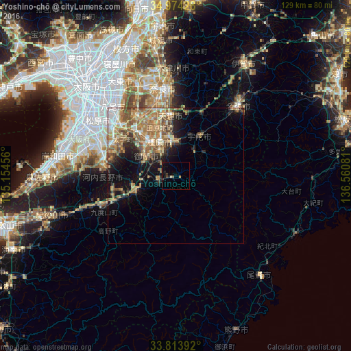
Analysis of Yoshino-chō night lights 2016
Square area 10x10 km:
 0%
0%90-99
0%80-89
0.7%70-79
0.7%60-69
0%50-59
0.7%40-49
0.7%30-39
1.4%20-29
0.7%10-19
4.2%0-9
90.91%Square area 50x50 km:
1.41%90-99
2.09%80-89
2.37%70-79
2.41%60-69
4.19%50-59
3.55%40-49
1.86%30-39
1.54%20-29
2.77%10-19
5.88%0-9
71.94%Clear (daylight) street map image can be seen on geolist.org.
Map coordinates:
34° 58' 27.4" North, 135° 9' 16.4" East
34° 23' 46" North, 135° 51' 27.6" East
33° 48' 50.1" North, 136° 33' 38.9" East
Some cities around Yoshino-chō sort by population:
• Kashihara-shi
13.9 km =8.6 mi,  334°
334°
• Tenri
20.9 km =13 mi,  353°
353°
• Sakurai
11.6 km =7.2 mi,  356°
356°
• Hashimoto
23.8 km =14.8 mi,  248°
248°
• Gojō
15.4 km =9.6 mi, 250°
• Gose
12.9 km =8 mi,  297°
297°
• Tawaramoto
18.6 km =11.6 mi,  341°
341°
• Haibara-akanedai
17.4 km =10.8 mi,  29°
29°
1848169 (p: 8,829)
Sources (retrieved 2019-11-25):
» Earth at Night: Flat Maps 2012, 2016