Kobayashi night lights from space
Night Light of Kobayashi (Miyazaki) from space (Japan) Src. Average luminocity for 10x10km area is 4.2115% and for 50x50km: 1.1569%.

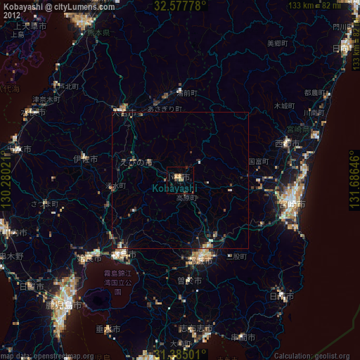
Analysis of Kobayashi night lights 2016
Square area 10x10 km:
 0%
0%90-99
0%80-89
0.7%70-79
1.22%60-69
1.4%50-59
0.17%40-49
1.05%30-39
0.7%20-29
1.75%10-19
0%0-9
93.01%Square area 50x50 km:
0.01%90-99
0.04%80-89
0.07%70-79
0.18%60-69
0.16%50-59
0.2%40-49
0.33%30-39
0.3%20-29
0.41%10-19
0.76%0-9
97.53%Clear (daylight) street map image can be seen on geolist.org.
Map coordinates:
32° 34' 40" North, 130° 16' 48.8" East
31° 58' 60" North, 130° 58' 60" East
31° 23' 6" North, 131° 41' 11.3" East
Some cities around Kobayashi sort by population:
• Miyakonojō
28.9 km =18 mi,  164°
164°
• Kokubu-matsuki
34.5 km =21.4 mi,  216°
216°
• Hamanoichi
37.9 km =23.5 mi, 218°
• Hitoyoshi
34 km =21.1 mi,  319°
319°
• Tsuma
41.4 km =25.7 mi,  71°
71°
• Kajiki
40.8 km =25.4 mi,  227°
227°
• Ōkuchi-shinohara
35.1 km =21.8 mi,  285°
285°
• Sueyoshichō-ninokata
37.2 km =23.1 mi,  175°
175°
1859175 (p: 39,747)
Sources (retrieved 2019-11-25):
» Earth at Night: Flat Maps 2012, 2016