Macherio night lights from space
Night Light of Macherio (Lombardy) from space (Italy) Src. Average luminocity for 10x10km area is 91.6288% and for 50x50km: 74.075%.
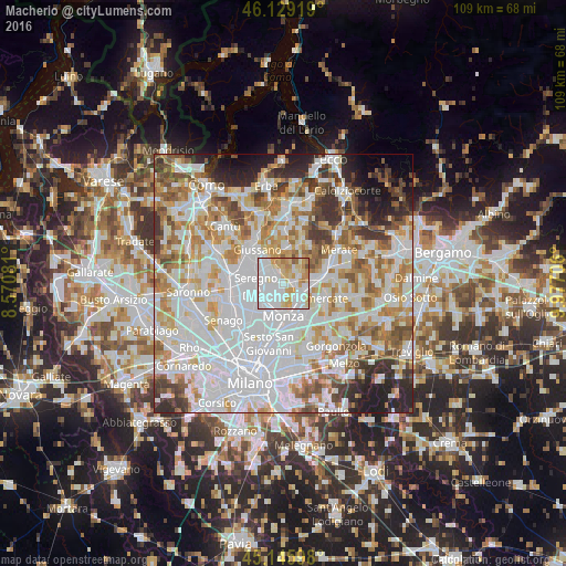
Analysis of Macherio night lights 2016
Square area 10x10 km:
 46.97%
90-99
20.45%80-89
13.33%70-79
12.73%60-69
4.55%50-59
1.52%40-49
0.45%30-39
0%20-29
0%10-19
0%0-9
0%Square area 50x50 km:
28.1%90-99
18.8%80-89
6.98%70-79
8.77%60-69
8.68%50-59
6.39%40-49
5.38%30-39
5.05%20-29
5.45%10-19
4.52%0-9
1.89%Clear (daylight) street map image can be seen on geolist.org.
Map coordinates:
46° 7' 45.1" North, 8° 34' 14.9" East
45° 38' 23.1" North, 9° 16' 26.2" East
45° 8' 45.5" North, 9° 58' 37.4" East
Some cities around Macherio sort by population:
• Lissone
4 km =2.5 mi,  221°
221°
• Arcore
4.2 km =2.6 mi,  110°
110°
• Villasanta
4.6 km =2.9 mi,  144°
144°
• Biassono
1.3 km =0.8 mi,  189°
189°
• Lesmo
2.8 km =1.7 mi,  69°
69°
• Sovico
1.1 km =0.7 mi,  308°
308°
• Vedano al Lambro
3.5 km =2.2 mi, 187°
• Albiate
2.5 km =1.6 mi, 313°
6534944 (p: 6,999)
Sources (retrieved 2019-11-25):
» Earth at Night: Flat Maps 2012, 2016