Villalba night lights from space
Night Light of Villalba (Latium) from space (Italy) Src. Average luminocity for 10x10km area is 67.5413% and for 50x50km: 45.4544%.
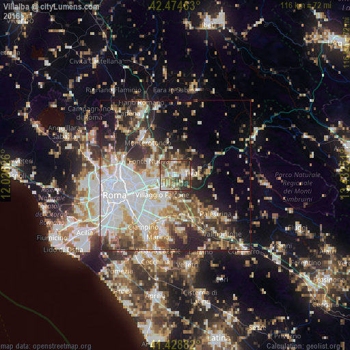
Analysis of Villalba night lights 2016
Square area 10x10 km:
 10.79%
90-99
16.83%80-89
7.62%70-79
8.89%60-69
14.92%50-59
14.76%40-49
11.43%30-39
10.95%20-29
3.81%10-19
0%0-9
0%Square area 50x50 km:
11.9%90-99
10.08%80-89
4.8%70-79
5.18%60-69
5.28%50-59
6.06%40-49
5.87%30-39
5.4%20-29
9.88%10-19
9.34%0-9
26.2%Clear (daylight) street map image can be seen on geolist.org.
Map coordinates:
42° 28' 28.7" North, 12° 1' 34.5" East
41° 57' 13.9" North, 12° 43' 45.8" East
41° 25' 43.8" North, 13° 25' 57" East
Some cities around Villalba sort by population:
• Guidonia Montecelio
4.5 km =2.8 mi,  352°
352°
• Tivoli
6 km =3.7 mi,  83°
83°
• Guidonia
4.4 km =2.7 mi, 348°
• Bagni di Tivoli
1.1 km =0.7 mi,  247°
247°
• Santa Lucia
6.8 km =4.2 mi,  297°
297°
• Marco Simone
6.8 km =4.2 mi,  271°
271°
• Marcellina
10 km =6.2 mi,  38°
38°
• Corcolle
5.6 km =3.5 mi,  173°
173°
8394394 (p: 8,831)
Sources (retrieved 2019-11-25):
» Earth at Night: Flat Maps 2012, 2016