Bagni di Tivoli night lights from space
Night Light of Bagni di Tivoli (Latium) from space (Italy) Src. Average luminocity for 10x10km area is 71.5206% and for 50x50km: 46.734%.
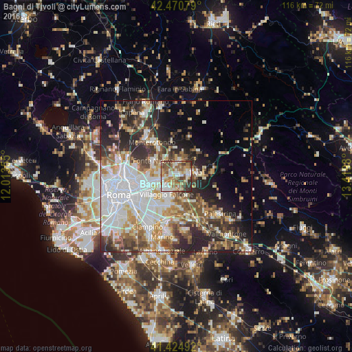
Analysis of Bagni di Tivoli night lights 2016
Square area 10x10 km:
 13.97%
90-99
19.21%80-89
9.21%70-79
8.57%60-69
14.76%50-59
14.13%40-49
9.21%30-39
9.05%20-29
1.9%10-19
0%0-9
0%Square area 50x50 km:
12.42%90-99
10.49%80-89
4.97%70-79
5.24%60-69
5.34%50-59
6.08%40-49
5.93%30-39
5.65%20-29
10.36%10-19
9.06%0-9
24.45%Clear (daylight) street map image can be seen on geolist.org.
Map coordinates:
42° 28' 14.8" North, 12° 0' 48.8" East
41° 57' 0" North, 12° 43' 0" East
41° 25' 29.7" North, 13° 25' 11.3" East
Some cities around Bagni di Tivoli sort by population:
• Guidonia Montecelio
4.9 km =3 mi,  5°
5°
• Guidonia
4.7 km =2.9 mi,  2°
2°
• Villanova
3.6 km =2.2 mi,  65°
65°
• Villa Adriana
4.6 km =2.9 mi,  83°
83°
• Villalba
1.1 km =0.7 mi, 67°
• Santa Lucia
6.2 km =3.9 mi,  305°
305°
• Marco Simone
5.7 km =3.5 mi,  276°
276°
• Corcolle
5.4 km =3.4 mi,  162°
162°
3182533 (p: 9,418)
Sources (retrieved 2019-11-25):
» Earth at Night: Flat Maps 2012, 2016