Villadose night lights from space
Night Light of Villadose (Veneto) from space (Italy) Src. Average luminocity for 10x10km area is 18.2091% and for 50x50km: 20.3776%.
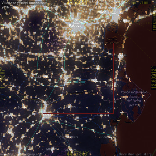
Analysis of Villadose night lights 2016
Square area 10x10 km:
 0%
0%90-99
0.61%80-89
2.73%70-79
1.21%60-69
1.97%50-59
2.58%40-49
5.3%30-39
6.06%20-29
6.52%10-19
26.21%0-9
46.82%Square area 50x50 km:
1.96%90-99
3%80-89
1.84%70-79
1.82%60-69
2.3%50-59
2.59%40-49
3.5%30-39
3.83%20-29
8.55%10-19
21.22%0-9
49.39%Clear (daylight) street map image can be seen on geolist.org.
Map coordinates:
45° 33' 59.7" North, 11° 11' 45.1" East
45° 4' 19.9" North, 11° 53' 56.4" East
44° 34' 24.5" North, 12° 36' 7.6" East
Some cities around Villadose sort by population:
• Rovigo
8.5 km =5.3 mi,  268°
268°
• Monselice
21.9 km =13.6 mi,  327°
327°
• Adria
12.5 km =7.8 mi,  99°
99°
• Cavarzere
16.2 km =10.1 mi,  64°
64°
• Copparo
20.8 km =12.9 mi,  196°
196°
• Conselve
17.8 km =11.1 mi,  353°
353°
• Lendinara
23.3 km =14.5 mi, 272°
• Solesino
16.9 km =10.5 mi,  314°
314°
3164254 (p: 5,086)
Sources (retrieved 2019-11-25):
» Earth at Night: Flat Maps 2012, 2016