Villa Adriana night lights from space
Night Light of Villa Adriana (Latium) from space (Italy) Src. Average luminocity for 10x10km area is 55.7175% and for 50x50km: 41.8594%.
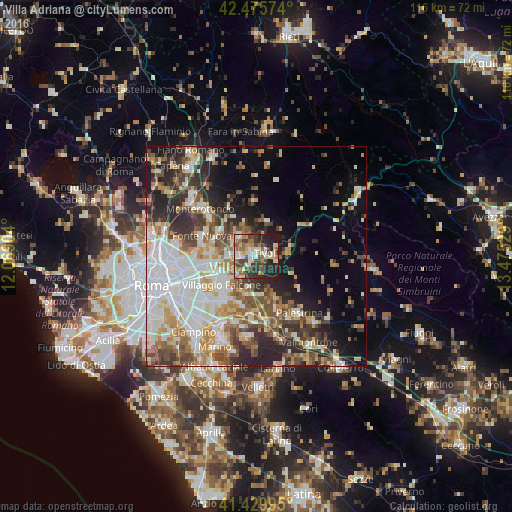
Analysis of Villa Adriana night lights 2016
Square area 10x10 km:
 7.14%
7.14%90-99
13.02%80-89
7.62%70-79
6.51%60-69
8.25%50-59
9.68%40-49
11.9%30-39
10%20-29
17.46%10-19
8.41%0-9
0%Square area 50x50 km:
9.85%90-99
9.04%80-89
4.61%70-79
5.15%60-69
4.99%50-59
5.79%40-49
5.73%30-39
5.22%20-29
9.47%10-19
9.24%0-9
30.9%Clear (daylight) street map image can be seen on geolist.org.
Map coordinates:
42° 28' 32.7" North, 12° 4' 8.5" East
41° 57' 18" North, 12° 46' 19.8" East
41° 25' 47.8" North, 13° 28' 31" East
Some cities around Villa Adriana sort by population:
• Guidonia Montecelio
5.9 km =3.7 mi,  316°
316°
• Tivoli
2.5 km =1.6 mi,  78°
78°
• Guidonia
6.1 km =3.8 mi,  313°
313°
• Bagni di Tivoli
4.6 km =2.9 mi,  263°
263°
• Santa Lucia
10.1 km =6.3 mi,  287°
287°
• Marcellina
8.2 km =5.1 mi,  19°
19°
• Castel Madama
8.2 km =5.1 mi, 75°
• Corcolle
6.4 km =4 mi,  207°
207°
7506720 (p: 12,008)
Sources (retrieved 2019-11-25):
» Earth at Night: Flat Maps 2012, 2016