Trasacco night lights from space
Night Light of Trasacco (Abruzzo) from space (Italy) Src. Average luminocity for 10x10km area is 8.2254% and for 50x50km: 9.2891%.
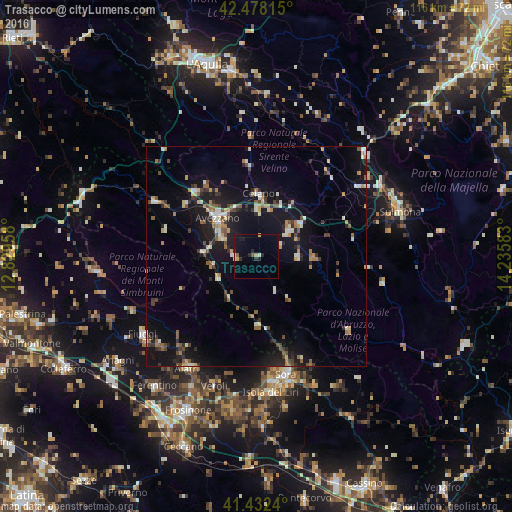
Analysis of Trasacco night lights 2016
Square area 10x10 km:
 0.32%
0.32%90-99
1.59%80-89
0.32%70-79
1.27%60-69
0%50-59
1.11%40-49
0.16%30-39
0.63%20-29
3.65%10-19
5.71%0-9
85.24%Square area 50x50 km:
0.5%90-99
1.52%80-89
0.85%70-79
1.01%60-69
1.23%50-59
1.2%40-49
1.38%30-39
1.17%20-29
2.39%10-19
9.65%0-9
79.09%Clear (daylight) street map image can be seen on geolist.org.
Map coordinates:
42° 28' 41.3" North, 12° 49' 46.5" East
41° 57' 26.7" North, 13° 31' 57.7" East
41° 25' 56.6" North, 14° 14' 9" East
Some cities around Trasacco sort by population:
• Avezzano
11.9 km =7.4 mi,  312°
312°
• Sora
27.4 km =17 mi,  165°
165°
• Isola del Liri
30.6 km =19 mi, 169°
• Alatri
29.7 km =18.5 mi,  212°
212°
• Celano
13.8 km =8.6 mi,  354°
354°
• Fiuggi
31.1 km =19.3 mi,  235°
235°
• Pratola Peligna
32.2 km =20 mi,  61°
61°
• Luco dei Marsi
4.9 km =3 mi,  272°
272°
3165314 (p: 6,144)
Sources (retrieved 2019-11-25):
» Earth at Night: Flat Maps 2012, 2016