Trabia night lights from space
Night Light of Trabia (Sicily) from space (Italy) Src. Average luminocity for 10x10km area is 21.5049% and for 50x50km: 10.4689%.
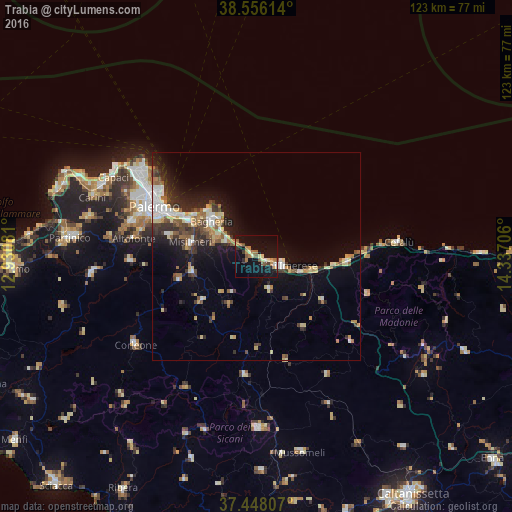
Analysis of Trabia night lights 2016
Square area 10x10 km:
 1.14%
1.14%90-99
0.81%80-89
3.9%70-79
2.6%60-69
5.19%50-59
4.71%40-49
1.62%30-39
2.11%20-29
1.95%10-19
32.63%0-9
43.34%Square area 50x50 km:
1.48%90-99
1.21%80-89
1.63%70-79
1.02%60-69
1.17%50-59
1.64%40-49
1.34%30-39
1.83%20-29
2.69%10-19
7.03%0-9
78.98%Clear (daylight) street map image can be seen on geolist.org.
Map coordinates:
38° 33' 22.1" North, 12° 55' 50.9" East
38° 0' 15.1" North, 13° 38' 2.1" East
37° 26' 53.1" North, 14° 20' 13.4" East
Some cities around Trabia sort by population:
• Bagheria
13.5 km =8.4 mi,  307°
307°
• Termini Imerese
6.1 km =3.8 mi,  113°
113°
• Misilmeri
16.6 km =10.3 mi,  280°
280°
• Ficarazzi
17.8 km =11.1 mi,  303°
303°
• Casteldaccia
10.5 km =6.5 mi, 299°
• Santa Flavia
14.2 km =8.8 mi,  321°
321°
• Caccamo
8.4 km =5.2 mi,  159°
159°
• Altavilla Milicia
8.3 km =5.2 mi, 296°
2522883 (p: 9,276)
Sources (retrieved 2019-11-25):
» Earth at Night: Flat Maps 2012, 2016