Altavilla Milicia night lights from space
Night Light of Altavilla Milicia (Sicily) from space (Italy) Src. Average luminocity for 10x10km area is 34.6867% and for 50x50km: 14.2232%.
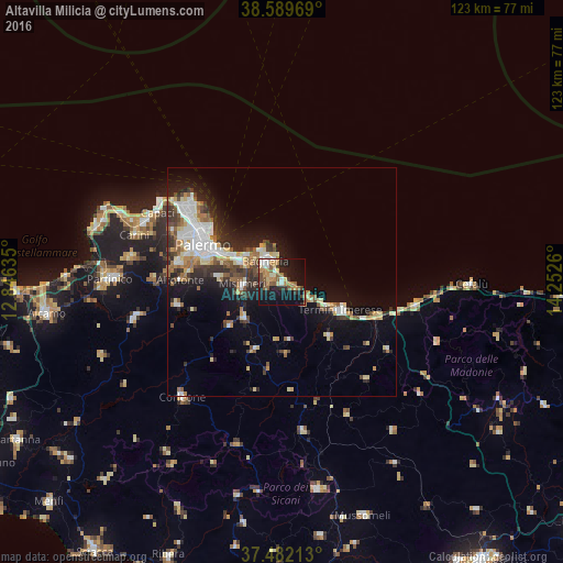
Analysis of Altavilla Milicia night lights 2016
Square area 10x10 km:
 4.06%
4.06%90-99
3.57%80-89
4.06%70-79
4.22%60-69
7.31%50-59
9.74%40-49
3.41%30-39
2.92%20-29
9.74%10-19
31.98%0-9
18.99%Square area 50x50 km:
2.62%90-99
2.15%80-89
1.87%70-79
1.25%60-69
1.78%50-59
2.08%40-49
1.82%30-39
2.36%20-29
3.48%10-19
8.39%0-9
72.2%Clear (daylight) street map image can be seen on geolist.org.
Map coordinates:
38° 35' 22.9" North, 12° 50' 46.9" East
38° 2' 16.8" North, 13° 32' 58.1" East
37° 28' 55.7" North, 14° 15' 9.4" East
Some cities around Altavilla Milicia sort by population:
• Bagheria
5.6 km =3.5 mi,  324°
324°
• Misilmeri
8.9 km =5.5 mi,  265°
265°
• Villabate
10.3 km =6.4 mi,  295°
295°
• Ficarazzi
9.6 km =6 mi,  308°
308°
• Casteldaccia
2.2 km =1.4 mi, 311°
• Santa Flavia
7.5 km =4.7 mi,  349°
349°
• Trabia
8.3 km =5.2 mi,  116°
116°
• Ciaculli
13.1 km =8.1 mi,  288°
288°
2525734 (p: 5,151)
Sources (retrieved 2019-11-25):
» Earth at Night: Flat Maps 2012, 2016