Ferrandina night lights from space
Night Light of Ferrandina (Basilicate) from space (Italy) Src. Average luminocity for 10x10km area is 10.8605% and for 50x50km: 5.2661%.
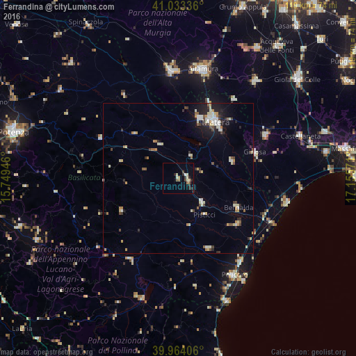
Analysis of Ferrandina night lights 2016
Square area 10x10 km:
 0%
0%90-99
2.72%80-89
2.04%70-79
0.51%60-69
1.53%50-59
1.36%40-49
0.68%30-39
2.72%20-29
3.4%10-19
0%0-9
85.03%Square area 50x50 km:
0.62%90-99
0.99%80-89
0.66%70-79
0.55%60-69
0.4%50-59
0.56%40-49
0.54%30-39
0.77%20-29
1.12%10-19
2.4%0-9
91.38%Clear (daylight) street map image can be seen on geolist.org.
Map coordinates:
41° 2' 0.1" North, 15° 44' 58.1" East
40° 30' 3" North, 16° 27' 9.3" East
39° 57' 50.6" North, 17° 9' 20.6" East
Some cities around Ferrandina sort by population:
• Matera
22.4 km =13.9 mi,  34°
34°
• Ginosa
27 km =16.8 mi,  71°
71°
• Bernalda
22.3 km =13.9 mi,  116°
116°
• Montescaglioso
18.8 km =11.7 mi, 73°
• Marconia
25.1 km =15.6 mi,  127°
127°
• Montalbano Jonico
25.9 km =16.1 mi,  157°
157°
• Pisticci
15.3 km =9.5 mi,  143°
143°
• Grassano
20.9 km =13 mi,  315°
315°
3177094 (p: 8,718)
Sources (retrieved 2019-11-25):
» Earth at Night: Flat Maps 2012, 2016