Policoro night lights from space
Night Light of Policoro (Basilicate) from space (Italy) Src. Average luminocity for 10x10km area is 32.0406% and for 50x50km: 4.9832%.
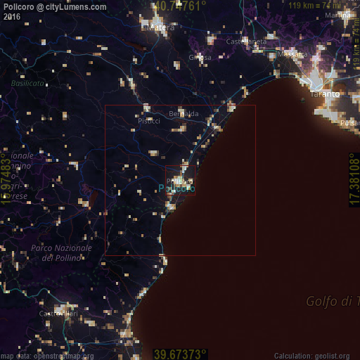
Analysis of Policoro night lights 2016
Square area 10x10 km:
 2.76%
2.76%90-99
9.58%80-89
3.57%70-79
3.57%60-69
3.9%50-59
3.25%40-49
2.44%30-39
0.49%20-29
5.68%10-19
45.62%0-9
19.16%Square area 50x50 km:
0.29%90-99
0.95%80-89
0.72%70-79
0.7%60-69
0.52%50-59
0.53%40-49
0.56%30-39
0.57%20-29
0.66%10-19
2.71%0-9
91.8%Clear (daylight) street map image can be seen on geolist.org.
Map coordinates:
40° 44' 51.4" North, 15° 58' 29.4" East
40° 12' 46.1" North, 16° 40' 40.6" East
39° 40' 25.4" North, 17° 22' 51.9" East
Some cities around Policoro sort by population:
• Bernalda
22.2 km =13.8 mi,  2°
2°
• Montescaglioso
37.5 km =23.3 mi,  358°
358°
• Marconia
16.8 km =10.4 mi, 2°
• Ferrandina
37.3 km =23.2 mi,  329°
329°
• Trebisacce
39.9 km =24.8 mi,  197°
197°
• Montalbano Jonico
12.3 km =7.6 mi,  311°
311°
• Senise
33.9 km =21.1 mi,  257°
257°
• Pisticci
22.1 km =13.7 mi, 332°
3170384 (p: 11,810)
Sources (retrieved 2019-11-25):
» Earth at Night: Flat Maps 2012, 2016