Santena night lights from space
Night Light of Santena (Piedmont) from space (Italy) Src. Average luminocity for 10x10km area is 42.2635% and for 50x50km: 33.9252%.
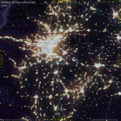
Analysis of Santena night lights 2016
Square area 10x10 km:
 6.35%
6.35%90-99
12.06%80-89
3.02%70-79
2.06%60-69
3.02%50-59
2.54%40-49
9.05%30-39
8.41%20-29
24.76%10-19
26.51%0-9
2.22%Square area 50x50 km:
7.87%90-99
7.8%80-89
2.48%70-79
2.78%60-69
3.67%50-59
4.2%40-49
4.84%30-39
4.91%20-29
7.54%10-19
17.39%0-9
36.52%Clear (daylight) street map image can be seen on geolist.org.
Map coordinates:
45° 26' 30.2" North, 7° 4' 11.7" East
44° 56' 46.5" North, 7° 46' 22.9" East
44° 26' 47.1" North, 8° 28' 34.2" East
Some cities around Santena sort by population:
• Moncalieri
9.3 km =5.8 mi,  309°
309°
• Chieri
8.1 km =5 mi,  27°
27°
• Trofarello
4.5 km =2.8 mi,  332°
332°
• La Loggia
8.3 km =5.2 mi,  276°
276°
• Carignano
9.1 km =5.7 mi,  240°
240°
• Pino Torinese
10.4 km =6.5 mi,  1°
1°
• Poirino
6.3 km =3.9 mi,  116°
116°
• Cambiano
2.8 km =1.7 mi, 2°
6534258 (p: 10,437)
Sources (retrieved 2019-11-25):
» Earth at Night: Flat Maps 2012, 2016