Poirino night lights from space
Night Light of Poirino (Piedmont) from space (Italy) Src. Average luminocity for 10x10km area is 19.2397% and for 50x50km: 30.5949%.
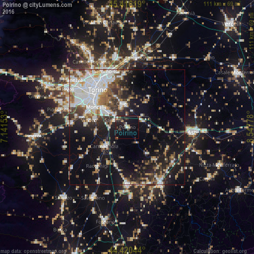
Analysis of Poirino night lights 2016
Square area 10x10 km:
 1.75%
1.75%90-99
1.75%80-89
2.22%70-79
0.95%60-69
1.11%50-59
1.59%40-49
4.6%30-39
3.49%20-29
7.46%10-19
30.63%0-9
44.44%Square area 50x50 km:
7.22%90-99
6.55%80-89
2.08%70-79
2.45%60-69
3.25%50-59
3.72%40-49
4.24%30-39
4.24%20-29
6.76%10-19
19.02%0-9
40.48%Clear (daylight) street map image can be seen on geolist.org.
Map coordinates:
45° 24' 58.3" North, 7° 8' 29.5" East
44° 55' 13.7" North, 7° 50' 40.7" East
44° 25' 13.6" North, 8° 32' 52" East
Some cities around Poirino sort by population:
• Chieri
10.2 km =6.3 mi,  349°
349°
• Carmagnola
12.6 km =7.8 mi,  231°
231°
• Trofarello
10.3 km =6.4 mi,  311°
311°
• Santena
6.3 km =3.9 mi,  296°
296°
• La Loggia
14.4 km =8.9 mi,  285°
285°
• Carignano
13.6 km =8.5 mi,  263°
263°
• Pino Torinese
14.3 km =8.9 mi,  338°
338°
• Cambiano
7.9 km =4.9 mi,  315°
315°
3170408 (p: 6,686)
Sources (retrieved 2019-11-25):
» Earth at Night: Flat Maps 2012, 2016