Motta Sant'Anastasia night lights from space
Night Light of Motta Sant'Anastasia (Sicily) from space (Italy) Src. Average luminocity for 10x10km area is 51.1153% and for 50x50km: 24.591%.
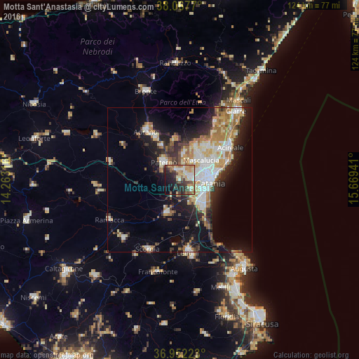
Analysis of Motta Sant'Anastasia night lights 2016
Square area 10x10 km:
 7.14%
7.14%90-99
6.98%80-89
11.2%70-79
10.71%60-69
7.47%50-59
4.87%40-49
6.98%30-39
8.77%20-29
15.42%10-19
14.94%0-9
5.52%Square area 50x50 km:
4.23%90-99
4.64%80-89
3.58%70-79
3.52%60-69
3.91%50-59
2.17%40-49
2.13%30-39
3.42%20-29
5.92%10-19
11.66%0-9
54.82%Clear (daylight) street map image can be seen on geolist.org.
Map coordinates:
38° 4' 3.7" North, 14° 15' 47.4" East
37° 30' 43.4" North, 14° 57' 58.6" East
36° 57' 8" North, 15° 40' 9.9" East
Some cities around Motta Sant'Anastasia sort by population:
• Catania
9.4 km =5.8 mi,  103°
103°
• Paternò
8.3 km =5.2 mi,  317°
317°
• Misterbianco
3.8 km =2.4 mi,  80°
80°
• Mascalucia
10.1 km =6.3 mi,  46°
46°
• Gravina di Catania
10.1 km =6.3 mi,  57°
57°
• Belpasso
9 km =5.6 mi,  7°
7°
• Sant'Agata Li Battiati
11.2 km =7 mi, 63°
• San Pietro Clarenza
8 km =5 mi,  38°
38°
2524041 (p: 9,025)
Sources (retrieved 2019-11-25):
» Earth at Night: Flat Maps 2012, 2016