Montegranaro night lights from space
Night Light of Montegranaro (The Marches) from space (Italy) Src. Average luminocity for 10x10km area is 50.7152% and for 50x50km: 21.7805%.
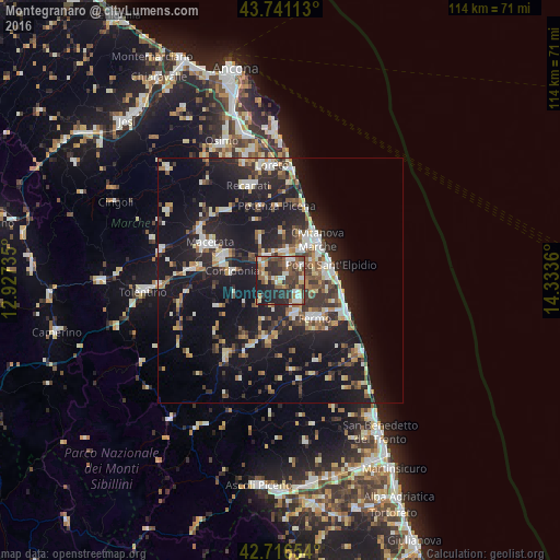
Analysis of Montegranaro night lights 2016
Square area 10x10 km:
 6.06%
6.06%90-99
10.91%80-89
3.48%70-79
6.67%60-69
6.82%50-59
10.91%40-49
11.82%30-39
11.52%20-29
18.94%10-19
12.88%0-9
0%Square area 50x50 km:
2.33%90-99
4.14%80-89
1.96%70-79
2.47%60-69
2.02%50-59
3.13%40-49
2.93%30-39
3.49%20-29
7.69%10-19
23.99%0-9
45.85%Clear (daylight) street map image can be seen on geolist.org.
Map coordinates:
43° 44' 28.1" North, 12° 55' 38.5" East
43° 13' 51.6" North, 13° 37' 49.7" East
42° 42' 59.5" North, 14° 20' 1" East
Some cities around Montegranaro sort by population:
• Civitanova Marche
11 km =6.8 mi,  41°
41°
• Macerata
16.2 km =10.1 mi,  297°
297°
• Porto Sant'Elpidio
10.7 km =6.6 mi,  76°
76°
• Fermo
10.6 km =6.6 mi,  135°
135°
• Porto San Giorgio
14.5 km =9 mi,  114°
114°
• Corridonia
10.2 km =6.3 mi,  279°
279°
• Porto Potenza Picena
15.1 km =9.4 mi,  21°
21°
• Sant'Elpidio a Mare
4.7 km =2.9 mi,  91°
91°
3172896 (p: 11,493)
Sources (retrieved 2019-11-25):
» Earth at Night: Flat Maps 2012, 2016