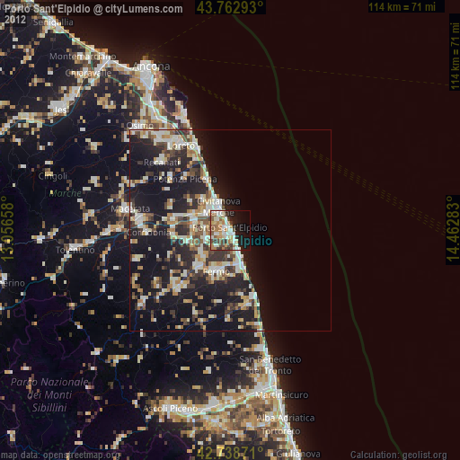
Porto Sant'Elpidio night lights from space
Night Light of Porto Sant'Elpidio (The Marches) from space (Italy) Src. Average luminocity for 10x10km area is 45.8% and for 50x50km: 18.818%.
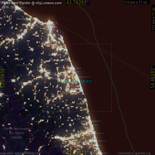
Analysis of Porto Sant'Elpidio night lights 2016
Square area 10x10 km:
 8.33%
8.33%90-99
9.39%80-89
6.52%70-79
5.76%60-69
3.33%50-59
9.55%40-49
7.12%30-39
5.91%20-29
12.27%10-19
17.73%0-9
14.09%Square area 50x50 km:
2.1%90-99
3.62%80-89
1.82%70-79
2.4%60-69
1.65%50-59
2.73%40-49
2.72%30-39
3.34%20-29
6.88%10-19
19.14%0-9
53.6%Clear (daylight) street map image can be seen on geolist.org.
Map coordinates:
43° 45' 46.5" North, 13° 3' 23.7" East
43° 15' 10.7" North, 13° 45' 34.9" East
42° 44' 19.4" North, 14° 27' 46.2" East
Some cities around Porto Sant'Elpidio sort by population:
• Civitanova Marche
6.6 km =4.1 mi,  331°
331°
• Fermo
10.4 km =6.5 mi,  196°
196°
• Recanati
23.6 km =14.7 mi,  315°
315°
• Montegranaro
10.7 km =6.6 mi,  256°
256°
• Corridonia
20.5 km =12.7 mi,  268°
268°
• Monte Urano
10.6 km =6.6 mi,  228°
228°
• Monte San Giusto
13.6 km =8.5 mi, 261°
• Sant'Elpidio a Mare
6.3 km =3.9 mi,  246°
246°
3170072 (p: 22,233)
Sources (retrieved 2019-11-25):
» Earth at Night: Flat Maps 2012, 2016