Menfi night lights from space
Night Light of Menfi (Sicily) from space (Italy) Src. Average luminocity for 10x10km area is 12.6531% and for 50x50km: 6.4759%.
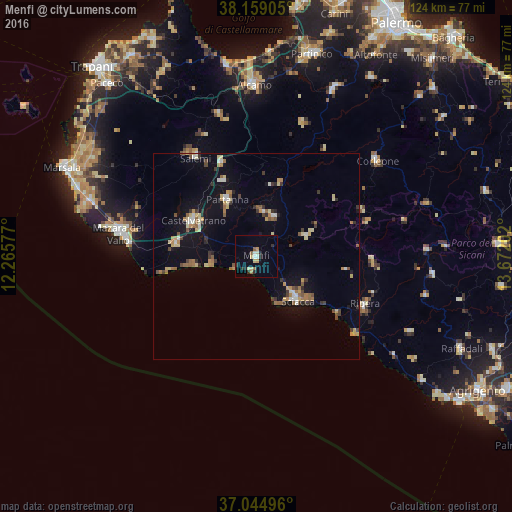
Analysis of Menfi night lights 2016
Square area 10x10 km:
 1.36%
1.36%90-99
1.02%80-89
3.06%70-79
1.36%60-69
0.85%50-59
1.87%40-49
0%30-39
1.53%20-29
3.74%10-19
1.19%0-9
84.01%Square area 50x50 km:
0.54%90-99
0.54%80-89
1.02%70-79
0.76%60-69
1.03%50-59
0.9%40-49
0.66%30-39
1.02%20-29
0.75%10-19
4.12%0-9
88.67%Clear (daylight) street map image can be seen on geolist.org.
Map coordinates:
38° 9' 32.6" North, 12° 15' 56.8" East
37° 36' 14.7" North, 12° 58' 8" East
37° 2' 41.9" North, 13° 40' 19.3" East
Some cities around Menfi sort by population:
• Sciacca
14.8 km =9.2 mi,  136°
136°
• Castelvetrano
17.8 km =11.1 mi,  298°
298°
• Ribera
28.8 km =17.9 mi,  114°
114°
• Partanna
15.3 km =9.5 mi,  332°
332°
• Campobello di Mazara
19.6 km =12.2 mi,  279°
279°
• Salemi
28.2 km =17.5 mi, 329°
• Santa Margherita di Belice
10.7 km =6.6 mi,  22°
22°
• Sambuca di Sicilia
13.9 km =8.6 mi,  67°
67°
2524179 (p: 11,874)
Sources (retrieved 2019-11-25):
» Earth at Night: Flat Maps 2012, 2016