Castelvetrano night lights from space
Night Light of Castelvetrano (Sicily) from space (Italy) Src. Average luminocity for 10x10km area is 25.7024% and for 50x50km: 9.2353%.

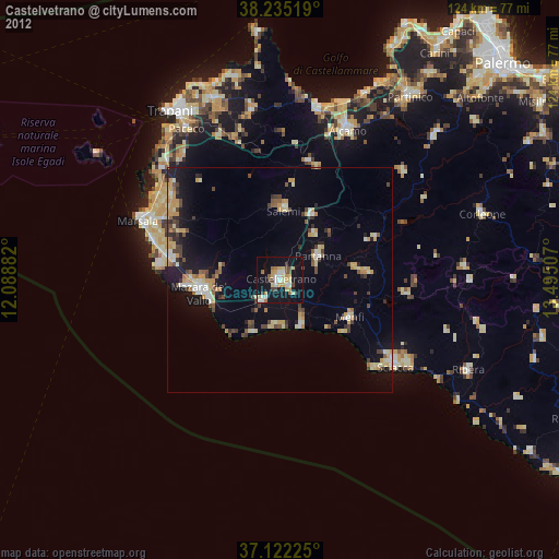
Analysis of Castelvetrano night lights 2016
Square area 10x10 km:
 2.72%
2.72%90-99
4.25%80-89
4.76%70-79
1.53%60-69
4.42%50-59
3.74%40-49
1.36%30-39
2.38%20-29
2.55%10-19
38.78%0-9
33.5%Square area 50x50 km:
0.73%90-99
0.87%80-89
1.4%70-79
1.14%60-69
1.64%50-59
1.04%40-49
1.02%30-39
1.31%20-29
1.85%10-19
8.06%0-9
80.94%Clear (daylight) street map image can be seen on geolist.org.
Map coordinates:
38° 14' 6.7" North, 12° 5' 19.8" East
37° 40' 50.9" North, 12° 47' 31" East
37° 7' 20.1" North, 13° 29' 42.3" East
Some cities around Castelvetrano sort by population:
• Mazara del Vallo
18 km =11.2 mi,  260°
260°
• Menfi
17.8 km =11.1 mi,  118°
118°
• Partanna
10 km =6.2 mi,  59°
59°
• Campobello di Mazara
6.4 km =4 mi,  216°
216°
• Salemi
15.7 km =9.8 mi,  4°
4°
• Petrosino
26 km =16.2 mi,  277°
277°
• Santa Margherita di Belice
19.7 km =12.2 mi,  86°
86°
• Sambuca di Sicilia
28.6 km =17.8 mi,  96°
96°
2525083 (p: 28,072)
Sources (retrieved 2019-11-25):
» Earth at Night: Flat Maps 2012, 2016