Mandello del Lario night lights from space
Night Light of Mandello del Lario (Lombardy) from space (Italy) Src. Average luminocity for 10x10km area is 9.689% and for 50x50km: 26.5338%.
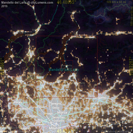
Analysis of Mandello del Lario night lights 2016
Square area 10x10 km:
 0.3%
0.3%90-99
0.89%80-89
0.6%70-79
0.89%60-69
0.6%50-59
1.19%40-49
0.3%30-39
1.49%20-29
4.32%10-19
14.88%0-9
74.55%Square area 50x50 km:
4.52%90-99
5.56%80-89
2.94%70-79
3.8%60-69
4.2%50-59
3.69%40-49
3.73%30-39
4.2%20-29
4.55%10-19
8.06%0-9
54.74%Clear (daylight) street map image can be seen on geolist.org.
Map coordinates:
46° 24' 32.2" North, 8° 36' 59.8" East
45° 55' 19.2" North, 9° 19' 11.1" East
45° 25' 50.6" North, 10° 1' 22.3" East
Some cities around Mandello del Lario sort by population:
• Lecco
9.5 km =5.9 mi,  140°
140°
• Erba
14.5 km =9 mi,  209°
209°
• Calolziocorte
16.8 km =10.4 mi,  147°
147°
• Valmadrera-Caserta
8.9 km =5.5 mi,  160°
160°
• Oggiono
14.7 km =9.1 mi,  171°
171°
• Olginate
16.4 km =10.2 mi, 152°
• Albavilla
17.1 km =10.6 mi,  217°
217°
• Canzo
9 km =5.6 mi,  204°
204°
3174107 (p: 10,255)
Sources (retrieved 2019-11-25):
» Earth at Night: Flat Maps 2012, 2016