Canzo night lights from space
Night Light of Canzo (Lombardy) from space (Italy) Src. Average luminocity for 10x10km area is 34.7574% and for 50x50km: 39.5839%.
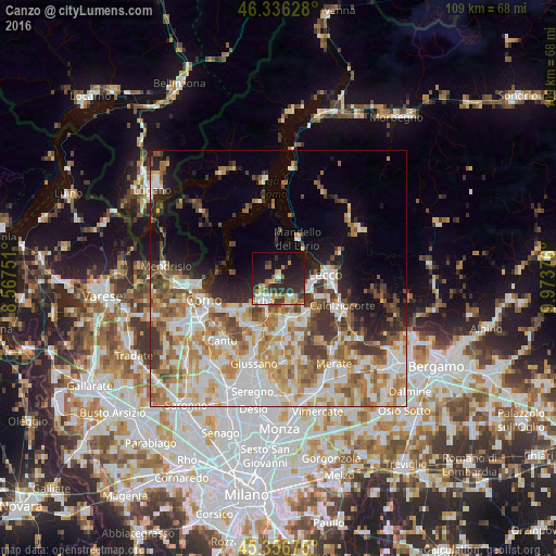
Analysis of Canzo night lights 2016
Square area 10x10 km:
 3.42%
3.42%90-99
5.21%80-89
3.42%70-79
6.85%60-69
3.87%50-59
4.02%40-49
4.17%30-39
6.25%20-29
20.24%10-19
26.79%0-9
15.77%Square area 50x50 km:
9.12%90-99
8.79%80-89
4.65%70-79
5.86%60-69
6.37%50-59
5.05%40-49
4.53%30-39
4.74%20-29
4.67%10-19
7.61%0-9
38.61%Clear (daylight) street map image can be seen on geolist.org.
Map coordinates:
46° 20' 10.6" North, 8° 34' 3" East
45° 50' 55.2" North, 9° 16' 14.3" East
45° 21' 24.3" North, 9° 58' 25.5" East
Some cities around Canzo sort by population:
• Lecco
9.8 km =6.1 mi,  85°
85°
• Erba
5.6 km =3.5 mi,  217°
217°
• Valmadrera-Caserta
6.8 km =4.2 mi, 92°
• Mandello del Lario
9 km =5.6 mi,  24°
24°
• Oggiono
8.8 km =5.5 mi,  136°
136°
• Vill'Albese
8.6 km =5.3 mi,  227°
227°
• Albavilla
8.5 km =5.3 mi, 231°
• Tavernerio
11.4 km =7.1 mi,  242°
242°
3180754 (p: 5,109)
Sources (retrieved 2019-11-25):
» Earth at Night: Flat Maps 2012, 2016