Fragagnano night lights from space
Night Light of Fragagnano (Apulia) from space (Italy) Src. Average luminocity for 10x10km area is 28.3878% and for 50x50km: 20.3368%.
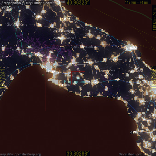
Analysis of Fragagnano night lights 2016
Square area 10x10 km:
 2.89%
2.89%90-99
4.76%80-89
3.23%70-79
2.89%60-69
2.21%50-59
0.68%40-49
4.25%30-39
4.76%20-29
4.76%10-19
69.05%0-9
0.51%Square area 50x50 km:
2.8%90-99
3.57%80-89
2.17%70-79
1.67%60-69
2.57%50-59
2.45%40-49
2.24%30-39
2.48%20-29
6.42%10-19
22.18%0-9
51.44%Clear (daylight) street map image can be seen on geolist.org.
Map coordinates:
40° 57' 47.8" North, 16° 46' 20.7" East
40° 25' 48.7" North, 17° 28' 31.9" East
39° 53' 34.3" North, 18° 10' 43.2" East
Some cities around Fragagnano sort by population:
• Grottaglie
12.3 km =7.6 mi,  344°
344°
• Sava
7.2 km =4.5 mi,  115°
115°
• San Giorgio Ionico
8.6 km =5.3 mi,  290°
290°
• Lizzano
4.8 km =3 mi,  211°
211°
• Pulsano
11.5 km =7.1 mi,  241°
241°
• San Marzano di San Giuseppe
3.6 km =2.2 mi,  41°
41°
• Carosino
7.6 km =4.7 mi,  300°
300°
• Monteiasi
11 km =6.8 mi,  314°
314°
3176616 (p: 5,098)
Sources (retrieved 2019-11-25):
» Earth at Night: Flat Maps 2012, 2016