Finale Ligure night lights from space
Night Light of Finale Ligure (Liguria) from space (Italy) Src. Average luminocity for 10x10km area is 22.3091% and for 50x50km: 10.101%.
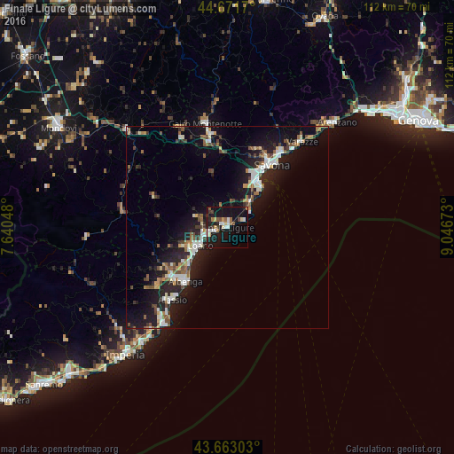
Analysis of Finale Ligure night lights 2016
Square area 10x10 km:
 2.42%
2.42%90-99
4.24%80-89
2.58%70-79
1.82%60-69
2.42%50-59
2.58%40-49
2.42%30-39
1.67%20-29
2.58%10-19
38.79%0-9
38.48%Square area 50x50 km:
1.23%90-99
1.93%80-89
0.72%70-79
0.78%60-69
1.09%50-59
1.43%40-49
1.41%30-39
1.22%20-29
3.2%10-19
10.95%0-9
76.03%Clear (daylight) street map image can be seen on geolist.org.
Map coordinates:
44° 40' 18.1" North, 7° 38' 25.7" East
44° 10' 10.3" North, 8° 20' 37" East
43° 39' 46.9" North, 9° 2' 48.2" East
Some cities around Finale Ligure sort by population:
• Savona
18.8 km =11.7 mi,  34°
34°
• Albenga
16.6 km =10.3 mi,  216°
216°
• Loano
8.3 km =5.2 mi,  235°
235°
• Pietra Ligure
5.4 km =3.4 mi,  245°
245°
• Vado Ligure
13.2 km =8.2 mi, 32°
• Carcare
21 km =13 mi,  348°
348°
• Vado Centro
13.1 km =8.1 mi, 32°
• Ceriale
12.6 km =7.8 mi,  226°
226°
3176982 (p: 9,495)
Sources (retrieved 2019-11-25):
» Earth at Night: Flat Maps 2012, 2016