Montegrotto Terme night lights from space
Night Light of Montegrotto Terme (Veneto) from space (Italy) Src. Average luminocity for 10x10km area is 64.3032% and for 50x50km: 42.5989%.
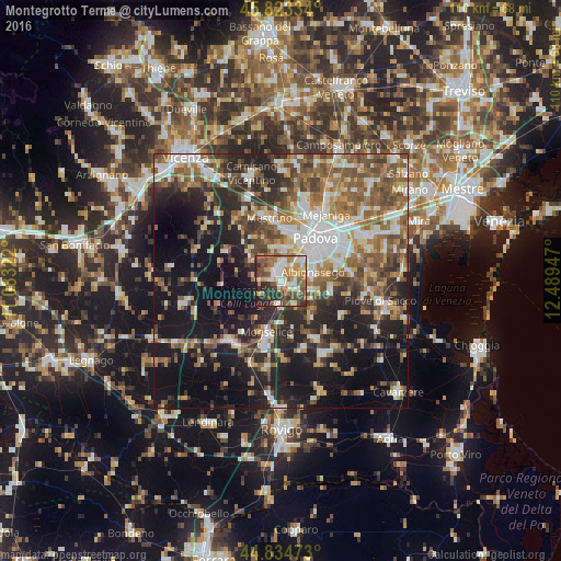
Analysis of Montegrotto Terme night lights 2016
Square area 10x10 km:
 11.75%
90-99
13.97%80-89
5.4%70-79
11.9%60-69
11.75%50-59
10.63%40-49
13.65%30-39
8.89%20-29
10.79%10-19
1.27%0-9
0%Square area 50x50 km:
6.32%90-99
8.16%80-89
3.98%70-79
4.94%60-69
6.34%50-59
9.08%40-49
8.06%30-39
6.04%20-29
11.53%10-19
21.96%0-9
13.59%Clear (daylight) street map image can be seen on geolist.org.
Map coordinates:
45° 49' 24" North, 11° 4' 59.6" East
45° 19' 52.3" North, 11° 47' 10.8" East
44° 50' 5" North, 12° 29' 22.1" East
Some cities around Montegrotto Terme sort by population:
• Abano Terme
2.9 km =1.8 mi,  1°
1°
• Albignasego
6.6 km =4.1 mi,  74°
74°
• Carrara San Giorgio
5 km =3.1 mi,  149°
149°
• Selvazzano Dentro
6.3 km =3.9 mi, 4°
• Tencarola
7.3 km =4.5 mi,  14°
14°
• Mandriola-Sant'Agostino
6.6 km =4.1 mi,  50°
50°
• Maserà di Padova
6.3 km =3.9 mi,  103°
103°
• Torreglia
4 km =2.5 mi,  278°
278°
3172890 (p: 10,276)
Sources (retrieved 2019-11-25):
» Earth at Night: Flat Maps 2012, 2016