Castiglion Fiorentino night lights from space
Night Light of Castiglion Fiorentino (Tuscany) from space (Italy) Src. Average luminocity for 10x10km area is 13.6095% and for 50x50km: 9.4742%.
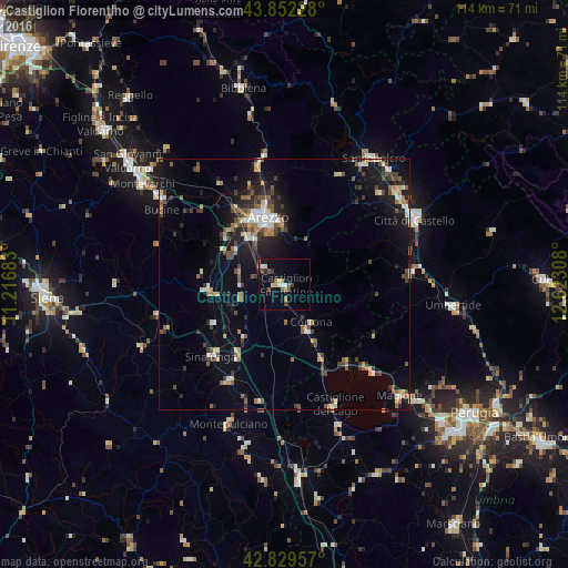
Analysis of Castiglion Fiorentino night lights 2016
Square area 10x10 km:
 1.27%
1.27%90-99
1.9%80-89
1.27%70-79
2.06%60-69
0.79%50-59
3.02%40-49
2.38%30-39
1.43%20-29
0.48%10-19
6.51%0-9
78.89%Square area 50x50 km:
0.83%90-99
1.14%80-89
1.08%70-79
0.95%60-69
1.02%50-59
1.71%40-49
1.73%30-39
1.51%20-29
2.31%10-19
6.61%0-9
81.11%Clear (daylight) street map image can be seen on geolist.org.
Map coordinates:
43° 51' 8.2" North, 11° 13' 0.6" East
43° 20' 35.1" North, 11° 55' 11.8" East
42° 49' 46.5" North, 12° 37' 23.1" East
Some cities around Castiglion Fiorentino sort by population:
• Arezzo
13.7 km =8.5 mi,  346°
346°
• Città di Castello
29 km =18 mi,  62°
62°
• Sansepolcro
31 km =19.3 mi,  34°
34°
• Sinalunga
20.1 km =12.5 mi,  224°
224°
• Magione
32.5 km =20.2 mi,  133°
133°
• Foiano della Chiana
13 km =8.1 mi, 219°
• Camucia-Monsigliolo
10.2 km =6.3 mi,  156°
156°
• Torrita di Siena
21.9 km =13.6 mi,  210°
210°
3179405 (p: 8,315)
Sources (retrieved 2019-11-25):
» Earth at Night: Flat Maps 2012, 2016