Casalpusterlengo night lights from space
Night Light of Casalpusterlengo (Lombardy) from space (Italy) Src. Average luminocity for 10x10km area is 45.2667% and for 50x50km: 29.0717%.
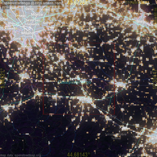
Analysis of Casalpusterlengo night lights 2016
Square area 10x10 km:
 8.64%
8.64%90-99
12.58%80-89
3.64%70-79
3.03%60-69
3.64%50-59
4.24%40-49
1.97%30-39
8.48%20-29
29.55%10-19
24.24%0-9
0%Square area 50x50 km:
3.87%90-99
5.12%80-89
2.49%70-79
2.6%60-69
3.24%50-59
3.57%40-49
3.29%30-39
4.91%20-29
13.44%10-19
30.42%0-9
27.03%Clear (daylight) street map image can be seen on geolist.org.
Map coordinates:
45° 40' 21.6" North, 8° 56' 42.8" East
45° 10' 45.2" North, 9° 38' 54" East
44° 40' 53.1" North, 10° 21' 5.3" East
Some cities around Casalpusterlengo sort by population:
• Piacenza
14.5 km =9 mi,  165°
165°
• Lodi
18.6 km =11.6 mi,  321°
321°
• Codogno
4.6 km =2.9 mi,  114°
114°
• Sant'Angelo Lodigiano
19.9 km =12.4 mi,  288°
288°
• Soresina
20.4 km =12.7 mi,  53°
53°
• San Nicolò
14 km =8.7 mi,  193°
193°
• Castelleone
15.7 km =9.8 mi,  34°
34°
• San Colombano al Lambro
12.4 km =7.7 mi,  272°
272°
3180168 (p: 12,674)
Sources (retrieved 2019-11-25):
» Earth at Night: Flat Maps 2012, 2016