Carnate night lights from space
Night Light of Carnate (Lombardy) from space (Italy) Src. Average luminocity for 10x10km area is 85.2955% and for 50x50km: 70.1794%.
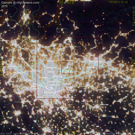
Analysis of Carnate night lights 2016
Square area 10x10 km:
 24.09%
90-99
28.64%80-89
12.42%70-79
13.94%60-69
13.18%50-59
5.45%40-49
2.27%30-39
0%20-29
0%10-19
0%0-9
0%Square area 50x50 km:
26.88%90-99
16.9%80-89
6.23%70-79
8.48%60-69
8.01%50-59
6.11%40-49
5%30-39
5.25%20-29
7.1%10-19
6.29%0-9
3.76%Clear (daylight) street map image can be seen on geolist.org.
Map coordinates:
46° 8' 16.1" North, 8° 40' 30" East
45° 38' 54.3" North, 9° 22' 41.3" East
45° 9' 17.1" North, 10° 4' 52.5" East
Some cities around Carnate sort by population:
• Vimercate
3.8 km =2.4 mi,  192°
192°
• Arcore
4.8 km =3 mi,  239°
239°
• Merate
5.6 km =3.5 mi,  36°
36°
• Bernareggio
2.1 km =1.3 mi,  91°
91°
• Usmate-Velate
1.2 km =0.7 mi,  267°
267°
• Lesmo
5.5 km =3.4 mi, 270°
• Bellusco
4.5 km =2.8 mi,  135°
135°
• Robbiate
6.4 km =4 mi,  45°
45°
3180483 (p: 7,164)
Sources (retrieved 2019-11-25):
» Earth at Night: Flat Maps 2012, 2016