Bovalino night lights from space
Night Light of Bovalino (Calabria) from space (Italy) Src. Average luminocity for 10x10km area is 24.3061% and for 50x50km: 6.9719%.
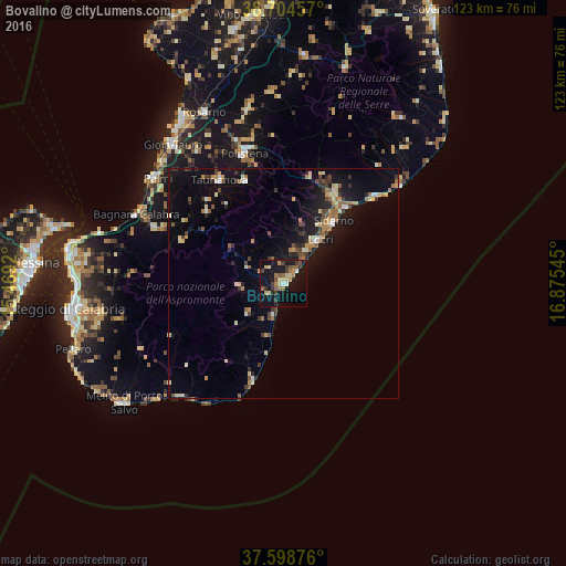
Analysis of Bovalino night lights 2016
Square area 10x10 km:
 1.19%
1.19%90-99
1.19%80-89
5.78%70-79
2.55%60-69
4.25%50-59
4.76%40-49
1.7%30-39
5.44%20-29
2.89%10-19
32.82%0-9
37.41%Square area 50x50 km:
0.37%90-99
0.68%80-89
1.1%70-79
0.83%60-69
1.07%50-59
0.97%40-49
0.83%30-39
1.23%20-29
1.16%10-19
6.79%0-9
84.98%Clear (daylight) street map image can be seen on geolist.org.
Map coordinates:
38° 42' 16.5" North, 15° 28' 9.1" East
38° 9' 13.5" North, 16° 10' 20.4" East
37° 35' 55.5" North, 16° 52' 31.6" East
Some cities around Bovalino sort by population:
• Siderno
16.8 km =10.4 mi,  39°
39°
• Taurianova
26.4 km =16.4 mi,  328°
328°
• Locri
12.1 km =7.5 mi, 38°
• Polistena
29.3 km =18.2 mi,  342°
342°
• Cittanova
23.7 km =14.7 mi, 339°
• Roccella Ionica
27 km =16.8 mi,  46°
46°
• Gioiosa Ionica
22.5 km =14 mi,  30°
30°
• Marina di Gioiosa Ionica
21.5 km =13.4 mi, 40°
2525513 (p: 7,514)
Sources (retrieved 2019-11-25):
» Earth at Night: Flat Maps 2012, 2016