Borgo a Buggiano night lights from space
Night Light of Borgo a Buggiano (Tuscany) from space (Italy) Src. Average luminocity for 10x10km area is 58.8651% and for 50x50km: 30.0912%.
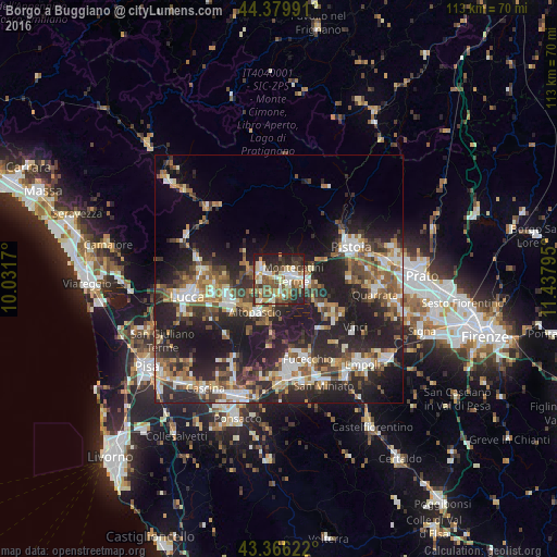
Analysis of Borgo a Buggiano night lights 2016
Square area 10x10 km:
 9.37%
9.37%90-99
13.65%80-89
6.98%70-79
6.51%60-69
10%50-59
10.79%40-49
12.22%30-39
8.73%20-29
16.67%10-19
5.08%0-9
0%Square area 50x50 km:
3.93%90-99
5.18%80-89
2.59%70-79
3.51%60-69
4.42%50-59
4.75%40-49
5.61%30-39
5.09%20-29
13.69%10-19
18.96%0-9
32.27%Clear (daylight) street map image can be seen on geolist.org.
Map coordinates:
44° 22' 47.7" North, 10° 1' 54.1" East
43° 52' 30.8" North, 10° 44' 5.4" East
43° 21' 58.4" North, 11° 26' 16.6" East
Some cities around Borgo a Buggiano sort by population:
• Capannori
13.5 km =8.4 mi,  254°
254°
• Montecatini-Terme
3.1 km =1.9 mi,  76°
76°
• Monsummano Terme
6.3 km =3.9 mi,  98°
98°
• Pescia
3.9 km =2.4 mi,  289°
289°
• Altopascio
8.1 km =5 mi,  215°
215°
• Pieve a Nievole
5.3 km =3.3 mi, 82°
• Porcari
10.2 km =6.3 mi, 248°
• Margine Coperta-Traversagna
1.9 km =1.2 mi,  74°
74°
3181819 (p: 7,302)
Sources (retrieved 2019-11-25):
» Earth at Night: Flat Maps 2012, 2016