Altopascio night lights from space
Night Light of Altopascio (Tuscany) from space (Italy) Src. Average luminocity for 10x10km area is 47.3152% and for 50x50km: 32.0432%.
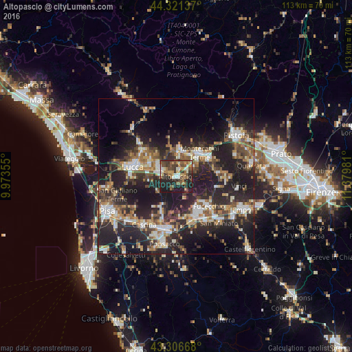
Analysis of Altopascio night lights 2016
Square area 10x10 km:
 3.64%
3.64%90-99
7.58%80-89
5.45%70-79
6.06%60-69
7.88%50-59
10.45%40-49
12.73%30-39
11.36%20-29
17.58%10-19
17.27%0-9
0%Square area 50x50 km:
4.09%90-99
5.57%80-89
2.83%70-79
3.68%60-69
4.29%50-59
4.62%40-49
5.94%30-39
5.63%20-29
15.15%10-19
22.4%0-9
25.79%Clear (daylight) street map image can be seen on geolist.org.
Map coordinates:
44° 19' 16.9" North, 9° 58' 24.8" East
43° 48' 58.2" North, 10° 40' 36" East
43° 18' 24" North, 11° 22' 47.3" East
Some cities around Altopascio sort by population:
• Capannori
8.8 km =5.5 mi,  288°
288°
• Montecatini-Terme
10.6 km =6.6 mi,  46°
46°
• Pescia
7.9 km =4.9 mi,  6°
6°
• Pieve a Nievole
12.2 km =7.6 mi, 53°
• Borgo a Buggiano
8.1 km =5 mi,  35°
35°
• Porcari
5.6 km =3.5 mi,  300°
300°
• Margine Coperta-Traversagna
9.6 km =6 mi, 42°
• Santa Maria a Monte
12.1 km =7.5 mi,  174°
174°
3183147 (p: 9,413)
Sources (retrieved 2019-11-25):
» Earth at Night: Flat Maps 2012, 2016