Bagnoli night lights from space
Night Light of Bagnoli (Campania) from space (Italy) Src. Average luminocity for 10x10km area is 59.869% and for 50x50km: 36.9201%.
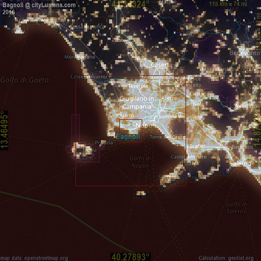

Analysis of Bagnoli night lights 2016
Square area 10x10 km:
100  20.92%
90-99 16.33%
80-89 6.8%
70-79 5.61%
60-69 3.4%
50-59 1.19%
40-49 3.74%
30-39 5.95%
20-29 16.33%
10-19 17.86%
0-9 1.87%
20.92%90-99
16.33%80-89
6.8%70-79
5.61%60-69
3.4%50-59
1.19%40-49
3.74%30-39
5.95%20-29
16.33%10-19
17.86%0-9
1.87%Square area 50x50 km:
100 10.7%
90-99 9.02%
80-89 3.98%
70-79 4.5%
60-69 4.31%
50-59 4.32%
40-49 2.18%
30-39 3.94%
20-29 5.19%
10-19 10.14%
0-9 41.71%
10.7%90-99
9.02%80-89
3.98%70-79
4.5%60-69
4.31%50-59
4.32%40-49
2.18%30-39
3.94%20-29
5.19%10-19
10.14%0-9
41.71%Clear (daylight) street map image can be seen on geolist.org.
Map coordinates:
41° 20' 35.7" North, 13° 27' 53.8" East
40° 48' 47.6" North, 14° 10' 5.1" East
40° 16' 44.1" North, 14° 52' 16.3" East
Some cities around Bagnoli sort by population:
• Fuorigrotta
3.5 km =2.2 mi,  50°
50°
• Arenella
6.7 km =4.2 mi,  43°
43°
• Pianura
5.1 km =3.2 mi,  4°
4°
• Pozzuoli
7 km =4.3 mi,  299°
299°
• Soccavo
4.1 km =2.5 mi,  29°
29°
• Vomero
6.2 km =3.9 mi,  58°
58°
• Chiaia
5.4 km =3.4 mi,  66°
66°
• Posillipo
2.7 km =1.7 mi,  91°
91°
3182518 (p: 23,333)
Sources (retrieved 2019-11-25):
» Earth at Night: Flat Maps 2012, 2016