Abbadia San Salvatore night lights from space
Night Light of Abbadia San Salvatore (Tuscany) from space (Italy) Src. Average luminocity for 10x10km area is 7.0444% and for 50x50km: 2.9832%.
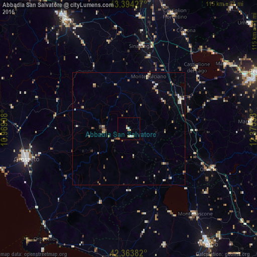
Analysis of Abbadia San Salvatore night lights 2016
Square area 10x10 km:
 0.95%
0.95%90-99
1.11%80-89
1.11%70-79
1.59%60-69
1.59%50-59
0.63%40-49
0%30-39
0%20-29
0%10-19
0%0-9
93.02%Square area 50x50 km:
0.09%90-99
0.61%80-89
0.39%70-79
0.39%60-69
0.41%50-59
0.56%40-49
0.47%30-39
0.28%20-29
0.36%10-19
0.47%0-9
95.96%Clear (daylight) street map image can be seen on geolist.org.
Map coordinates:
43° 23' 39.4" North, 10° 58' 8.7" East
42° 52' 52.3" North, 11° 40' 19.9" East
42° 21' 49.8" North, 12° 22' 31.2" East
Some cities around Abbadia San Salvatore sort by population:
• Grosseto
47.7 km =29.6 mi,  254°
254°
• Montefiascone
47.8 km =29.7 mi,  142°
142°
• Sinalunga
37.6 km =23.4 mi,  9°
9°
• Foiano della Chiana
43 km =26.7 mi,  15°
15°
• Chianciano Terme
21.2 km =13.2 mi,  32°
32°
• Orvieto
40.2 km =25 mi,  116°
116°
• Torrita di Siena
33.6 km =20.9 mi, 15°
• Castiglione del Lago
40.3 km =25 mi,  47°
47°
3183581 (p: 6,364)
Sources (retrieved 2019-11-25):
» Earth at Night: Flat Maps 2012, 2016