Vāda night lights from space
Night Light of Vāda (Maharashtra) from space (India) Src. Average luminocity for 10x10km area is 18.3678% and for 50x50km: 9.2527%.
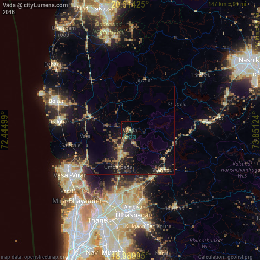
Analysis of Vāda night lights 2016
Square area 10x10 km:
 0%
0%90-99
0.62%80-89
1.86%70-79
5.37%60-69
3.1%50-59
3.93%40-49
2.07%30-39
3.93%20-29
5.17%10-19
16.74%0-9
57.23%Square area 50x50 km:
0%90-99
0.51%80-89
1.16%70-79
1.34%60-69
1.32%50-59
1.88%40-49
1.9%30-39
2.51%20-29
3.37%10-19
9.39%0-9
76.62%Clear (daylight) street map image can be seen on geolist.org.
Map coordinates:
20° 18' 51.3" North, 72° 26' 42" East
19° 39' 12.5" North, 73° 8' 53.2" East
18° 59' 23.8" North, 73° 51' 4.5" East
Some cities around Vāda sort by population:
• Bhiwandi
40.4 km =25.1 mi,  193°
193°
• Virār
41.6 km =25.8 mi,  238°
238°
• Pālghar
40.4 km =25.1 mi,  276°
276°
• Igatpuri
43.6 km =27.1 mi,  83°
83°
• Vasind
29.8 km =18.5 mi,  156°
156°
• Jawhār
29.9 km =18.6 mi,  15°
15°
• Shāhāpur
29.1 km =18.1 mi,  140°
140°
• Manor
26.2 km =16.3 mi,  287°
287°
1253610 (p: 15,474)
Sources (retrieved 2019-11-25):
» Earth at Night: Flat Maps 2012, 2016