Bishunpur Urf Mahārājganj night lights from space
Night Light of Bishunpur Urf Mahārājganj (Uttar Pradesh) from space (India) Src. Average luminocity for 10x10km area is 27.5298% and for 50x50km: 26.7846%.
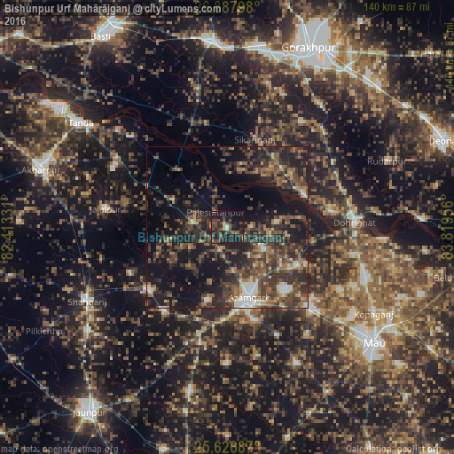
Analysis of Bishunpur Urf Mahārājganj night lights 2016
Square area 10x10 km:
 0.6%
0.6%90-99
0.99%80-89
1.19%70-79
1.59%60-69
1.59%50-59
7.14%40-49
12.7%30-39
8.13%20-29
15.28%10-19
39.88%0-9
10.91%Square area 50x50 km:
1.71%90-99
2.29%80-89
1.56%70-79
2.23%60-69
4.2%50-59
5.47%40-49
8.71%30-39
9.64%20-29
11.8%10-19
20.7%0-9
31.68%Clear (daylight) street map image can be seen on geolist.org.
Map coordinates:
26° 53' 16.7" North, 82° 24' 47.9" East
26° 15' 32.9" North, 83° 6' 59.1" East
25° 37' 36.7" North, 83° 49' 10.4" East
Some cities around Bishunpur Urf Mahārājganj sort by population:
• Azamgarh
22.3 km =13.9 mi,  162°
162°
• Mubārakpur
25.7 km =16 mi,  137°
137°
• Nizāmābād
23.7 km =14.7 mi,  194°
194°
• Bilariāganj
13.1 km =8.1 mi,  122°
122°
• Atraulia
18.8 km =11.7 mi,  296°
296°
• Jainpur
24.8 km =15.4 mi, 118°
• Gola Bāzār
25.4 km =15.8 mi,  68°
68°
• Phūlpur
31.3 km =19.4 mi,  229°
229°
1264435 (p: 7,499)
Sources (retrieved 2019-11-25):
» Earth at Night: Flat Maps 2012, 2016