Phirangipuram night lights from space
Night Light of Phirangipuram (Andhra Pradesh) from space (India) Src. Average luminocity for 10x10km area is 17.8905% and for 50x50km: 22.8164%.
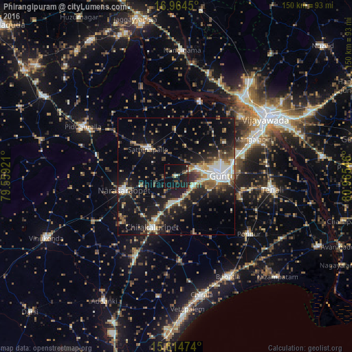
Analysis of Phirangipuram night lights 2016
Square area 10x10 km:
 0%
0%90-99
2.48%80-89
0.21%70-79
0.83%60-69
1.45%50-59
3.1%40-49
3.72%30-39
3.31%20-29
7.85%10-19
35.54%0-9
41.53%Square area 50x50 km:
1.79%90-99
4.88%80-89
2%70-79
1.74%60-69
2.88%50-59
4.23%40-49
3.76%30-39
3.98%20-29
7.15%10-19
18.3%0-9
49.29%Clear (daylight) street map image can be seen on geolist.org.
Map coordinates:
16° 57' 52.2" North, 79° 33' 33.2" East
16° 17' 26.8" North, 80° 15' 44.4" East
15° 36' 53.1" North, 80° 57' 55.7" East
Some cities around Phirangipuram sort by population:
• Guntur
20.8 km =12.9 mi,  87°
87°
• Narasaraopet
23.6 km =14.7 mi,  254°
254°
• Chilakalūrupet
24.5 km =15.2 mi,  204°
204°
• Mangalagiri
36.2 km =22.5 mi,  64°
64°
• Ponnūru
39.8 km =24.7 mi,  129°
129°
• Ponnur
39.2 km =24.4 mi, 128°
• Sattenapalle
16.4 km =10.2 mi,  314°
314°
• Tādepalle
41.9 km =26 mi, 59°
1259773 (p: 17,335)
Sources (retrieved 2019-11-25):
» Earth at Night: Flat Maps 2012, 2016