Nāzirā night lights from space
Night Light of Nāzirā (Assam) from space (India) Src. Average luminocity for 10x10km area is 14.627% and for 50x50km: 8.5517%.
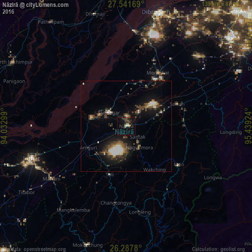
Analysis of Nāzirā night lights 2016
Square area 10x10 km:
100  0.6%
0.6%
90-99 1.39%
80-89 0.4%
70-79 1.98%
60-69 0.79%
50-59 1.59%
40-49 4.56%
30-39 3.97%
20-29 3.57%
10-19 9.13%
0-9 72.02%
0.6%90-99
1.39%80-89
0.4%70-79
1.98%60-69
0.79%50-59
1.59%40-49
4.56%30-39
3.97%20-29
3.57%10-19
9.13%0-9
72.02%Square area 50x50 km:
100 0.97%
90-99 1.16%
80-89 0.41%
70-79 0.59%
60-69 0.77%
50-59 1.41%
40-49 2.21%
30-39 2.18%
20-29 2.32%
10-19 6.33%
0-9 81.65%
0.97%90-99
1.16%80-89
0.41%70-79
0.59%60-69
0.77%50-59
1.41%40-49
2.21%30-39
2.18%20-29
2.32%10-19
6.33%0-9
81.65%Clear (daylight) street map image can be seen on geolist.org.
Map coordinates:
27° 32' 30.1" North, 94° 1' 58.8" East
26° 54' 59.4" North, 94° 44' 10" East
26° 17' 16.1" North, 95° 26' 21.3" East
Some cities around Nāzirā sort by population:
• Jorhāt
55.8 km =34.7 mi,  251°
251°
• Sibsāgar
12.3 km =7.6 mi,  307°
307°
• Mariāni
50.8 km =31.6 mi,  235°
235°
• Sonāri
30.3 km =18.8 mi,  66°
66°
• Mon
37.8 km =23.5 mi,  122°
122°
• Amguri
23.7 km =14.7 mi, 241°
• Titābar
63.4 km =39.4 mi, 236°
• Morānha
35 km =21.7 mi,  30°
30°
1261563 (p: 14,302)
Sources (retrieved 2019-11-25):
» Earth at Night: Flat Maps 2012, 2016