Manthani night lights from space
Night Light of Manthani (Telangana) from space (India) Src. Average luminocity for 10x10km area is 9.312% and for 50x50km: 14.5755%.
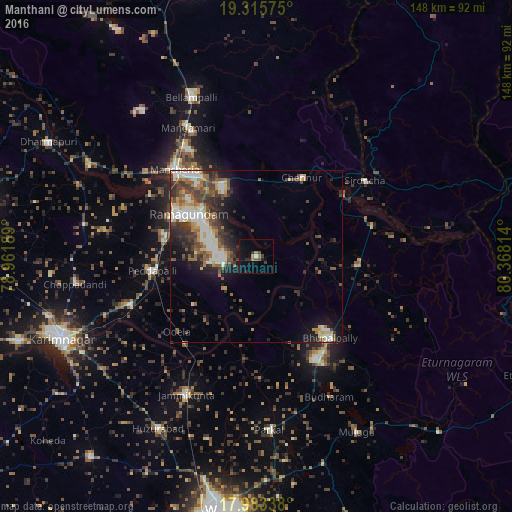
Analysis of Manthani night lights 2016
Square area 10x10 km:
 0.41%
0.41%90-99
0.41%80-89
0%70-79
0.83%60-69
2.48%50-59
0.83%40-49
1.86%30-39
1.45%20-29
3.51%10-19
9.3%0-9
78.93%Square area 50x50 km:
2.18%90-99
2.56%80-89
1.44%70-79
1.65%60-69
1.92%50-59
2.31%40-49
2.92%30-39
3.13%20-29
4.09%10-19
6.25%0-9
71.56%Clear (daylight) street map image can be seen on geolist.org.
Map coordinates:
19° 18' 56.7" North, 78° 57' 42.8" East
18° 39' 3.1" North, 79° 39' 54" East
17° 59' 0.2" North, 80° 22' 5.3" East
Some cities around Manthani sort by population:
• Rāmgundam
27.9 km =17.3 mi,  306°
306°
• Ramagundam
23.2 km =14.4 mi,  299°
299°
• Mancherāl
34.9 km =21.7 mi, 314°
• Bellampalli
48.5 km =30.1 mi,  338°
338°
• Mandamarri
40.3 km =25 mi,  330°
330°
• Peddapalli
30.9 km =19.2 mi,  262°
262°
• Nāspur
30.5 km =19 mi,  315°
315°
• Lakshettipet
53 km =32.9 mi, 296°
1263610 (p: 15,661)
Sources (retrieved 2019-11-25):
» Earth at Night: Flat Maps 2012, 2016