Mahroni night lights from space
Night Light of Mahroni (Uttar Pradesh) from space (India) Src. Average luminocity for 10x10km area is 10.7143% and for 50x50km: 8.2875%.
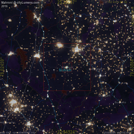
Analysis of Mahroni night lights 2016
Square area 10x10 km:
 0.99%
0.99%90-99
0.6%80-89
0.79%70-79
2.38%60-69
1.19%50-59
1.59%40-49
1.98%30-39
2.18%20-29
1.19%10-19
3.97%0-9
83.13%Square area 50x50 km:
0.86%90-99
1.05%80-89
0.51%70-79
0.68%60-69
0.77%50-59
1.55%40-49
1.71%30-39
2.28%20-29
2.6%10-19
5.35%0-9
82.63%Clear (daylight) street map image can be seen on geolist.org.
Map coordinates:
25° 13' 26.3" North, 78° 1' 28.5" East
24° 35' 10.5" North, 78° 43' 39.8" East
23° 56' 42.9" North, 79° 25' 51" East
Some cities around Mahroni sort by population:
• Lalitpur
33.3 km =20.7 mi,  290°
290°
• Tīkamgarh
20.3 km =12.6 mi,  30°
30°
• Jatāra
57.1 km =35.5 mi, 34°
• Shāhgarh
49.8 km =30.9 mi,  127°
127°
• Tālbahat
58.8 km =36.5 mi,  329°
329°
• Khargāpur
49.6 km =30.8 mi,  57°
57°
• Pāli
33.2 km =20.6 mi,  251°
251°
• Baldeogarh
39.2 km =24.4 mi, 61°
1264351 (p: 8,898)
Sources (retrieved 2019-11-25):
» Earth at Night: Flat Maps 2012, 2016