Mahgawān night lights from space
Night Light of Mahgawān (Madhya Pradesh) from space (India) Src. Average luminocity for 10x10km area is 10.3352% and for 50x50km: 5.6254%.
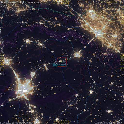
Analysis of Mahgawān night lights 2016
Square area 10x10 km:
 0%
0%90-99
1.7%80-89
1.52%70-79
1.14%60-69
2.84%50-59
0.76%40-49
2.27%30-39
0.95%20-29
1.89%10-19
1.52%0-9
85.42%Square area 50x50 km:
0.43%90-99
0.88%80-89
0.56%70-79
0.52%60-69
0.7%50-59
0.58%40-49
1.25%30-39
1.11%20-29
1.4%10-19
4.18%0-9
88.37%Clear (daylight) street map image can be seen on geolist.org.
Map coordinates:
27° 7' 20.1" North, 77° 54' 46.1" East
26° 29' 41" North, 78° 36' 57.3" East
25° 51' 49.4" North, 79° 19' 8.6" East
Some cities around Mahgawān sort by population:
• Bhind
18.8 km =11.7 mi,  64°
64°
• Gohadi
18.6 km =11.6 mi,  248°
248°
• Porsa
31.5 km =19.6 mi,  309°
309°
• Seondha
41.3 km =25.7 mi,  156°
156°
• Mau
26 km =16.2 mi,  167°
167°
• Mihona
43.2 km =26.8 mi,  122°
122°
• Bāh
41.7 km =25.9 mi,  356°
356°
• Umri
32 km =19.9 mi,  86°
86°
1264383 (p: 16,176)
Sources (retrieved 2019-11-25):
» Earth at Night: Flat Maps 2012, 2016