Lohogaon night lights from space
Night Light of Lohogaon (Maharashtra) from space (India) Src. Average luminocity for 10x10km area is 86.343% and for 50x50km: 59.4417%.
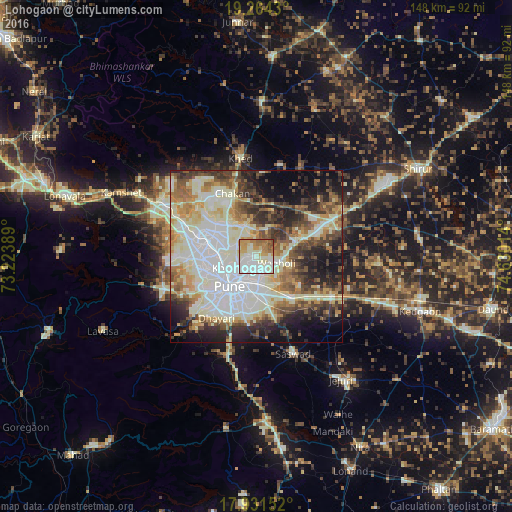
Analysis of Lohogaon night lights 2016
Square area 10x10 km:
 27.07%
90-99
32.44%80-89
9.92%70-79
13.02%60-69
9.3%50-59
6.61%40-49
1.45%30-39
0.21%20-29
0%10-19
0%0-9
0%Square area 50x50 km:
12.39%90-99
20.9%80-89
6.13%70-79
6.61%60-69
6.43%50-59
6.64%40-49
6.52%30-39
6.9%20-29
9.53%10-19
9.96%0-9
7.98%Clear (daylight) street map image can be seen on geolist.org.
Map coordinates:
19° 15' 51.5" North, 73° 13' 26" East
18° 35' 57.2" North, 73° 55' 37.2" East
17° 55' 53.5" North, 74° 37' 48.5" East
Some cities around Lohogaon sort by population:
• Pune
11.6 km =7.2 mi,  220°
220°
• Pimpri
12.9 km =8 mi,  281°
281°
• Shivaji Nagar
11 km =6.8 mi,  225°
225°
• Khadki
8.8 km =5.5 mi,  243°
243°
• Koregaon
14.8 km =9.2 mi,  69°
69°
• Chākan
19.1 km =11.9 mi,  339°
339°
• Alandi
9.2 km =5.7 mi, 341°
• Dehu
21.5 km =13.4 mi,  308°
308°
1264816 (p: 13,529)
Sources (retrieved 2019-11-25):
» Earth at Night: Flat Maps 2012, 2016