Kottapalli night lights from space
Night Light of Kottapalli (Telangana) from space (India) Src. Average luminocity for 10x10km area is 36.6074% and for 50x50km: 13.5068%.
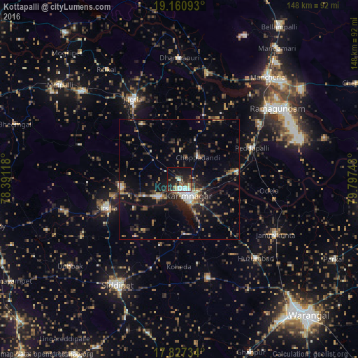
Analysis of Kottapalli night lights 2016
Square area 10x10 km:
 5.17%
5.17%90-99
8.68%80-89
2.48%70-79
3.72%60-69
5.17%50-59
3.93%40-49
3.31%30-39
9.09%20-29
15.08%10-19
23.97%0-9
19.42%Square area 50x50 km:
0.97%90-99
1.39%80-89
1.18%70-79
1.06%60-69
1.82%50-59
2.55%40-49
2.44%30-39
3.3%20-29
5.21%10-19
9.11%0-9
70.96%Clear (daylight) street map image can be seen on geolist.org.
Map coordinates:
19° 9' 39.3" North, 78° 23' 28.2" East
18° 29' 43.5" North, 79° 5' 39.5" East
17° 49' 38.4" North, 79° 47' 50.7" East
Some cities around Kottapalli sort by population:
• Ramagundam
49.3 km =30.6 mi,  54°
54°
• Karīmnagar
7.2 km =4.5 mi,  149°
149°
• Jagtiāl
38.2 km =23.7 mi,  330°
330°
• Sirsilla
32.2 km =20 mi,  248°
248°
• Siddipet
50.6 km =31.4 mi,  210°
210°
• Peddapalli
32.3 km =20.1 mi,  66°
66°
• Vemalwāda
24 km =14.9 mi,  261°
261°
• Lakshettipet
43.2 km =26.8 mi,  17°
17°
1265923 (p: 9,899)
Sources (retrieved 2019-11-25):
» Earth at Night: Flat Maps 2012, 2016