Katpur night lights from space
Night Light of Katpur (Gujarat) from space (India) Src. Average luminocity for 10x10km area is 13.1032% and for 50x50km: 2.4486%.
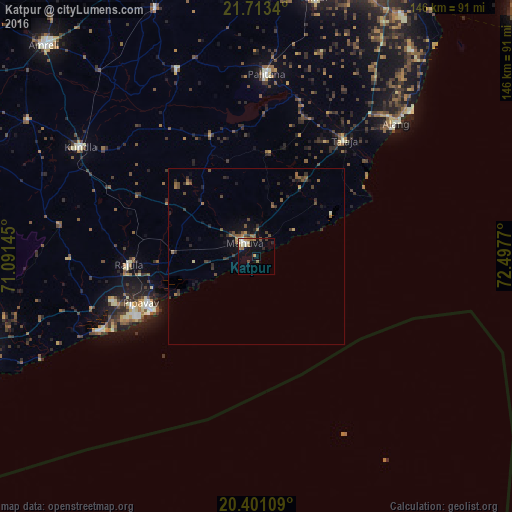
Analysis of Katpur night lights 2016
Square area 10x10 km:
 0%
0%90-99
4.37%80-89
1.19%70-79
0.4%60-69
3.97%50-59
1.98%40-49
1.19%30-39
0.4%20-29
1.59%10-19
9.13%0-9
75.79%Square area 50x50 km:
0%90-99
0.23%80-89
0.13%70-79
0.17%60-69
0.61%50-59
0.6%40-49
0.56%30-39
0.61%20-29
0.7%10-19
1.38%0-9
95%Clear (daylight) street map image can be seen on geolist.org.
Map coordinates:
21° 42' 48.2" North, 71° 5' 29.2" East
21° 3' 31.3" North, 71° 47' 40.5" East
20° 24' 3.9" North, 72° 29' 51.7" East
Some cities around Katpur sort by population:
• Kundla
59.6 km =37 mi,  301°
301°
• Savarkundla
59.6 km =37 mi, 301°
• Pālitāna
52 km =32.3 mi,  3°
3°
• Sihor
74.6 km =46.4 mi,  13°
13°
• Gariadhar
57.9 km =36 mi,  337°
337°
• Rājula
36.5 km =22.7 mi,  266°
266°
• Talāja
41.1 km =25.5 mi,  37°
37°
• Dungarpur
25.8 km =16 mi,  350°
350°
1267454 (p: 6,981)
Sources (retrieved 2019-11-25):
» Earth at Night: Flat Maps 2012, 2016