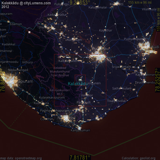
Kalakkādu night lights from space
Night Light of Kalakkādu (Tamil Nadu) from space (India) Src. Average luminocity for 10x10km area is 10.2624% and for 50x50km: 9.8163%.

Analysis of Kalakkādu night lights 2016
Square area 10x10 km:
 0.21%
0.21%90-99
1.03%80-89
0.41%70-79
0%60-69
2.07%50-59
2.69%40-49
2.89%30-39
2.89%20-29
5.17%10-19
2.89%0-9
79.75%Square area 50x50 km:
1.02%90-99
1.41%80-89
1%70-79
1.14%60-69
1.45%50-59
1.5%40-49
2.05%30-39
1.52%20-29
2.54%10-19
6.52%0-9
79.85%Clear (daylight) street map image can be seen on geolist.org.
Map coordinates:
9° 12' 30.7" North, 76° 50' 46.8" East
8° 30' 49.7" North, 77° 32' 58" East
7° 49' 4.1" North, 78° 15' 9.3" East
Some cities around Kalakkādu sort by population:
• Tirunelveli
28 km =17.4 mi,  31°
31°
• Ambasamudram
24.4 km =15.2 mi,  333°
333°
• Ālangulam
39.3 km =24.4 mi,  351°
351°
• Kallidaikurichi
21.2 km =13.2 mi, 334°
• Vadakku Valliyūr
16.1 km =10 mi,  154°
154°
• Padmanābhapuram
38.7 km =24 mi,  219°
219°
• Vadakku Viravanallur
20.7 km =12.9 mi, 350°
• Nanguneri
12.2 km =7.6 mi,  100°
100°
1268495 (p: 27,845)
Sources (retrieved 2019-11-25):
» Earth at Night: Flat Maps 2012, 2016