Hole Narsipur night lights from space
Night Light of Hole Narsipur (Karnataka) from space (India) Src. Average luminocity for 10x10km area is 19.3766% and for 50x50km: 7.6625%.
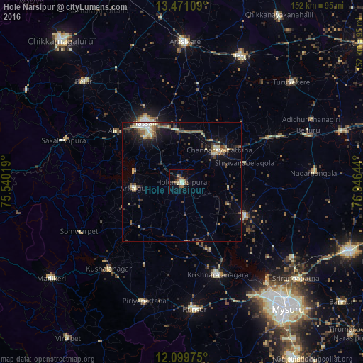

Analysis of Hole Narsipur night lights 2016
Square area 10x10 km:
 1.3%
1.3%90-99
3.03%80-89
3.46%70-79
0%60-69
3.03%50-59
5.84%40-49
1.52%30-39
3.68%20-29
3.25%10-19
4.98%0-9
69.91%Square area 50x50 km:
0.37%90-99
0.97%80-89
1.43%70-79
0.4%60-69
0.84%50-59
1.44%40-49
1.37%30-39
1.57%20-29
2.12%10-19
4.3%0-9
85.19%Clear (daylight) street map image can be seen on geolist.org.
Map coordinates:
13° 28' 15.9" North, 75° 32' 24.7" East
12° 47' 10.9" North, 76° 14' 35.9" East
12° 5' 59.1" North, 76° 56' 47.2" East
Some cities around Hole Narsipur sort by population:
• Hassan
29.3 km =18.2 mi,  326°
326°
• Channarāyapatna
20.6 km =12.8 mi,  49°
49°
• Krishnarājpet
29.7 km =18.5 mi,  116°
116°
• Arkalgūd
20 km =12.4 mi,  262°
262°
• Konanūr
27.2 km =16.9 mi,  230°
230°
• Alūr
34.7 km =21.6 mi,  307°
307°
• Gorūr
19.8 km =12.3 mi,  281°
281°
• Srāvana Belgola
27.8 km =17.3 mi,  73°
73°
1269985 (p: 28,285)
Sources (retrieved 2019-11-25):
» Earth at Night: Flat Maps 2012, 2016