Bhāyāvadar night lights from space
Night Light of Bhāyāvadar (Gujarat) from space (India) Src. Average luminocity for 10x10km area is 3.004% and for 50x50km: 3.7119%.
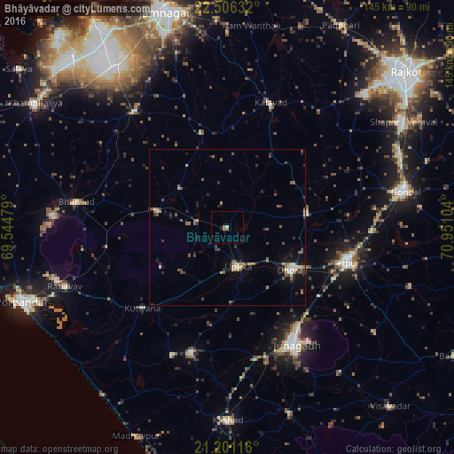
Analysis of Bhāyāvadar night lights 2016
Square area 10x10 km:
 0%
0%90-99
0%80-89
0.79%70-79
0%60-69
1.19%50-59
1.19%40-49
0%30-39
0%20-29
0.2%10-19
1.39%0-9
95.24%Square area 50x50 km:
0.19%90-99
0.27%80-89
0.44%70-79
0.39%60-69
0.56%50-59
0.88%40-49
0.75%30-39
0.72%20-29
0.92%10-19
1.79%0-9
93.1%Clear (daylight) street map image can be seen on geolist.org.
Map coordinates:
22° 30' 22.8" North, 69° 32' 41.2" East
21° 51' 18.8" North, 70° 14' 52.5" East
21° 12' 4.2" North, 70° 57' 3.7" East
Some cities around Bhāyāvadar sort by population:
• Jetpur
40.3 km =25 mi,  106°
106°
• Dhorāji
24.9 km =15.5 mi,  122°
122°
• Upleta
13.3 km =8.3 mi,  164°
164°
• Jodhpur
22.8 km =14.2 mi,  283°
283°
• Mānāvadar
41.3 km =25.7 mi,  195°
195°
• Kālāvad
41.6 km =25.8 mi,  19°
19°
• Kutiyāna
37.4 km =23.2 mi,  226°
226°
• Jetalsar
37.7 km =23.4 mi, 115°
1276013 (p: 19,458)
Sources (retrieved 2019-11-25):
» Earth at Night: Flat Maps 2012, 2016