Betūl Bazār night lights from space
Night Light of Betūl Bazār (Madhya Pradesh) from space (India) Src. Average luminocity for 10x10km area is 26.3968% and for 50x50km: 3.6933%.
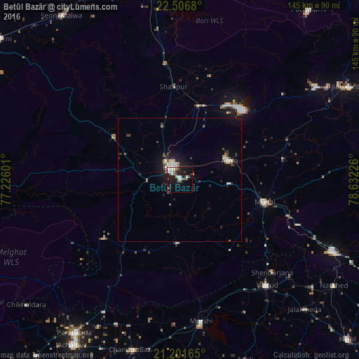
Analysis of Betūl Bazār night lights 2016
Square area 10x10 km:
 4.56%
4.56%90-99
5.36%80-89
2.38%70-79
1.59%60-69
2.78%50-59
3.77%40-49
3.17%30-39
3.77%20-29
4.56%10-19
28.17%0-9
39.88%Square area 50x50 km:
0.53%90-99
0.54%80-89
0.39%70-79
0.15%60-69
0.39%50-59
0.49%40-49
0.46%30-39
0.78%20-29
0.75%10-19
3.13%0-9
92.38%Clear (daylight) street map image can be seen on geolist.org.
Map coordinates:
22° 30' 24.5" North, 77° 13' 33.6" East
21° 51' 20.6" North, 77° 55' 44.9" East
21° 12' 5.9" North, 78° 37' 56.1" East
Some cities around Betūl Bazār sort by population:
• Warud
55.4 km =34.4 mi,  140°
140°
• Pāndhurnā
68.1 km =42.3 mi,  115°
115°
• Morsi
58 km =36 mi,  171°
171°
• Amla
21.9 km =13.6 mi,  69°
69°
• Multai
35.1 km =21.8 mi,  104°
104°
• Chāndūr Bāzār
71.2 km =44.2 mi,  195°
195°
• Bhainsdehi
38.8 km =24.1 mi,  232°
232°
• Mowād
69.3 km =43.1 mi,  128°
128°
1276388 (p: 9,640)
Sources (retrieved 2019-11-25):
» Earth at Night: Flat Maps 2012, 2016