Bagar night lights from space
Night Light of Bagar (Rajasthan) from space (India) Src. Average luminocity for 10x10km area is 8.2282% and for 50x50km: 4.6057%.
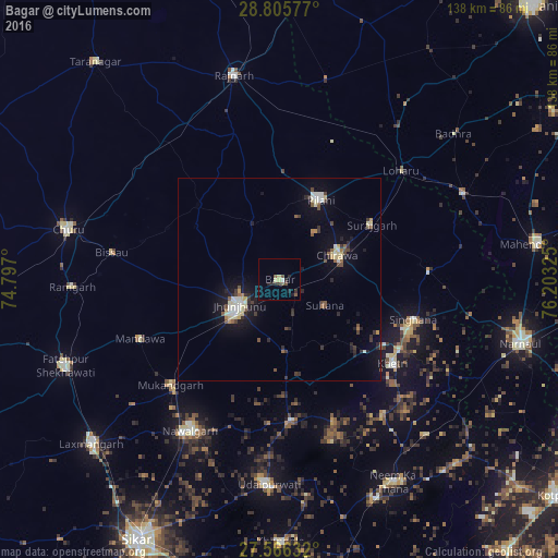
Analysis of Bagar night lights 2016
Square area 10x10 km:
 0%
0%90-99
0.79%80-89
2.38%70-79
0%60-69
0%50-59
1.79%40-49
2.38%30-39
1.59%20-29
4.37%10-19
0.99%0-9
85.71%Square area 50x50 km:
0.34%90-99
0.78%80-89
0.8%70-79
0.25%60-69
0.25%50-59
0.67%40-49
0.69%30-39
0.7%20-29
1.04%10-19
3.03%0-9
91.44%Clear (daylight) street map image can be seen on geolist.org.
Map coordinates:
28° 48' 20.8" North, 74° 47' 49.2" East
28° 11' 16.2" North, 75° 30' 0.4" East
27° 33' 58.8" North, 76° 12' 11.7" East
Some cities around Bagar sort by population:
• Jhunjhunūn
12.2 km =7.6 mi,  235°
235°
• Nawalgarh
43.5 km =27 mi,  210°
210°
• Chidawa
14.9 km =9.3 mi,  67°
67°
• Pilāni
22.4 km =13.9 mi,  26°
26°
• Bissāu
42 km =26.1 mi,  279°
279°
• Sūrajgarh
26.5 km =16.5 mi,  59°
59°
• Khetri
35 km =21.7 mi,  126°
126°
• Lohāru
40.4 km =25.1 mi,  48°
48°
1277930 (p: 15,670)
Sources (retrieved 2019-11-25):
» Earth at Night: Flat Maps 2012, 2016