Bu‘eina night lights from space
Night Light of Bu‘eina (Northern District) from space (Israel) Src. Average luminocity for 10x10km area is 65.7115% and for 50x50km: 56.1623%.
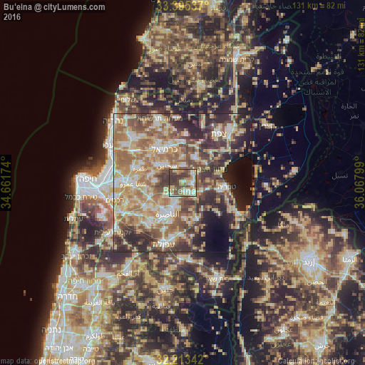
Analysis of Bu‘eina night lights 2016
Square area 10x10 km:
 10.14%
90-99
9.97%80-89
17.48%70-79
8.74%60-69
6.82%50-59
15.56%40-49
16.61%30-39
14.69%20-29
0%10-19
0%0-9
0%Square area 50x50 km:
6.84%90-99
8.58%80-89
13.3%70-79
9.24%60-69
10.29%50-59
9.08%40-49
9.85%30-39
9.21%20-29
10.29%10-19
7.39%0-9
5.94%Clear (daylight) street map image can be seen on geolist.org.
Map coordinates:
33° 23' 43.3" North, 34° 39' 42.3" East
32° 48' 22.9" North, 35° 21' 53.5" East
32° 12' 48.3" North, 36° 4' 4.8" East
Some cities around Bu‘eina sort by population:
• Nazareth
13.4 km =8.3 mi,  208°
208°
• Sakhnīn
9 km =5.6 mi,  315°
315°
• Maghār
10.1 km =6.3 mi,  22°
22°
• Kafr Kannā
7 km =4.3 mi,  197°
197°
• Er Reina
10.3 km =6.4 mi, 206°
• Kafr Mandā
9.8 km =6.1 mi,  272°
272°
• Deir Ḥannā
6.2 km =3.9 mi,  358°
358°
• Dabbūrīya
12.7 km =7.9 mi,  177°
177°
295380 (p: 7,900)
Sources (retrieved 2019-11-25):
» Earth at Night: Flat Maps 2012, 2016